IMAGES TAKEN NEAR TO
Upper Tything, WORCESTER, WR1 1JY
Introduction
This page details the photographs taken nearby to Upper Tything, WR1 1JY by members of the Geograph project.
The Geograph project started in 2005 with the aim of publishing, organising and preserving representative images for every square kilometre of Great Britain, Ireland and the Isle of Man.

There are currently over 7.5m images from over14,400 individuals and you can help contribute to the project by visiting https://www.geograph.org.uk
Image Map
Images are licensed for reuse under creativecommons.org/licenses/by-sa/2.0
Notes
- Clicking on the map will re-center to the selected point.
- The higher the marker number, the further away the image location is from the centre of the postcode.
Image Listing (267 Images Found)
Images are licensed for reuse under creativecommons.org/licenses/by-sa/2.0
Image
Details
Distance
1
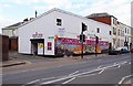
The former United Footwear store, 51a The Tything, Worcester
This branch of United Footwear closed down just over a year ago in late February 2015. It was closed because of "economic decline" according to a report in the local paper. The only externally attractive feature of this rather ugly building is the mural on the front. See:- Image
Image: © P L Chadwick
Taken: 28 Feb 2016
0.01 miles
2

Mural on front wall of 51a The Tything, Worcester
This is only part of the mural on the front wall of the former United Footwear store. Unfortunately the top is obscured by the closing down sale banner still remaining a year after the store closed. Worcester is known as the Faithful City because of its supposed loyalty to King Charles II in the Civil War. The story is too complicated to go into here. The full mural is difficult to photograph because of street furniture, but most of it can be seen in this February 2012 view by Peter Barr:- Image
Image: © P L Chadwick
Taken: 28 Feb 2016
0.01 miles
3
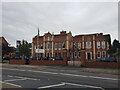
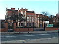
RGS Worcester, main entrance Upper Tything
The Royal Grammar School Worcester is an eleven-eighteen mixed, independent day school with linked prep-schools around Worcestershire.
Image: © Jeff Gogarty
Taken: 24 Aug 2022
0.03 miles
4

53 Britannia Square, Worcester
A detached house in this upmarket Regency development. The shell tympana above the ground-floor windows are in the manner of John Nash. Grade II listed.
Image: © Stephen Richards
Taken: 15 Jul 2014
0.03 miles
5
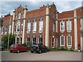
Alice Ottley School
Alice Ottley School is part of the Worcester Royal Grammar School and occupies Britannia House which is Grade II* listed https://www.historicengland.org.uk/listing/the-list/list-entry/1390240. The building dates from 1730-50 with later editions, it became a school in 1883; it stands on the east side of Upper Tything.
Image: © Philip Halling
Taken: 1 Jul 2008
0.03 miles
6
Alice Ottley School
Alice Ottley School is part of the Worcester Royal Grammar School and occupies Britannia House which is Grade II* listed https://www.historicengland.org.uk/listing/the-list/list-entry/1390240. The building dates from 1730-50 with later editions, it became a school in 1883; it stands on the east side of Upper Tything.
Image: © Philip Halling
Taken: 1 Jul 2008
0.03 miles
7
The Royal Grammar School Worcester
This is an independent coeducational school in Worcester. Founded before 1291, it is one of the oldest British independent day schools.
Image: © Eirian Evans
Taken: 8 Jan 2011
0.04 miles
8

United Footwear, Upper Tything
Mural on the wall of United Footwear, of Worcester's coat of arms and motto - Civitas in Bello et Pace Fidelis - Faithful City in Peace and War
Image: © Eirian Evans
Taken: 9 Jan 2011
0.04 miles
9
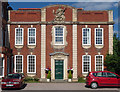
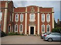
Britannia House, Upper Tything, Worcester
Good provincial Baroque, possibly by the distinctive hand of Thomas White, and dated c1730. White is known to have carved the figure of Britannia. Grade II* listed.
Now part of the Worcester Royal Grammar School.
Image: © Stephen Richards
Taken: 15 Jul 2014
0.04 miles
10
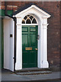
Detail of 24 The Tything, Worcester
Early C19th doorcase.
Wider view: Image
Image: © Stephen Richards
Taken: 15 Jul 2014
0.05 miles