IMAGES TAKEN NEAR TO
Foregate Street, WORCESTER, WR1 1DS
Introduction
This page details the photographs taken nearby to Foregate Street, WR1 1DS by members of the Geograph project.
The Geograph project started in 2005 with the aim of publishing, organising and preserving representative images for every square kilometre of Great Britain, Ireland and the Isle of Man.

There are currently over 7.5m images from over14,400 individuals and you can help contribute to the project by visiting https://www.geograph.org.uk
Image Map
Images are licensed for reuse under creativecommons.org/licenses/by-sa/2.0
Notes
- Clicking on the map will re-center to the selected point.
- The higher the marker number, the further away the image location is from the centre of the postcode.
Image Listing (766 Images Found)
Images are licensed for reuse under creativecommons.org/licenses/by-sa/2.0
Image
Details
Distance
2
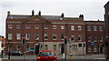
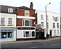
28-30 Foregate Street, Worcester
Late C18th. Nos 29-30 take the form of a large house in a 2-3-2 bay rhythm, to which an extra two bays has been added. However, it seems to have been built that way. Restored in 1996 after a fire. Decent doorcases (Image] and Image]). Grade II listed.
Image: © Stephen Richards
Taken: 15 Jul 2014
0.01 miles
3
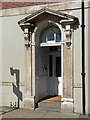
Detail of 29 Foregate Street, Worcester
Pedimented doorcase with consoles and fanlight with intersecting tracery.
Wider view: Image
Image: © Stephen Richards
Taken: 15 Jul 2014
0.01 miles
4
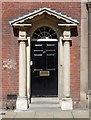
Detail of 28 Foregate Street, Worcester
Pedimented Doric doorcase.
Wider view: Image
Image: © Stephen Richards
Taken: 15 Jul 2014
0.01 miles

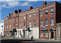
7
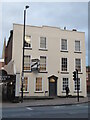
No. 1 The Tything, Worcester
A Grade II Listed former house that is now offices.
Image: © Chris Allen
Taken: 12 Nov 2021
0.02 miles
8
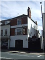
The Saracen's Head, Worcester
On The Tything.
Image: © JThomas
Taken: 22 Jul 2017
0.02 miles
9
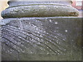
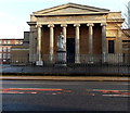
Nineteenth-century benchmark on Worcester County Court
This benchmark was established in 1844 during the First primary levelling of England & Wales, and was levelled with a height of 79.661 feet [24.281 metres] above mean sea level (Liverpool datum). It was included on the Manchester to Gloucester levelling line. The surveyor's description was "No. 383. Mark on face of stone work under pillar of portico of County Court House ; 2.11 ft. above centre of road" (Public Abstract p.34). The mark is faint and not easy to see on the weathered stonework, on the north face of the building, directly beneath the centre of the column.
Image: © Shantavira
Taken: 20 Nov 2015
0.03 miles
10
Queen Victoria statue in front of the Shire Hall, Worcester
Viewed across Foregate Street. Standing on a plinth, the statue of Queen Victoria in robes of state and carrying an orb and sceptre was erected in 1887 to celebrate the Golden Jubilee (50 years) of her reign. The statue was Grade II listed in 1971.
Image: © Jaggery
Taken: 29 Nov 2014
0.03 miles