IMAGES TAKEN NEAR TO
South Littleton, EVESHAM, WR11 8TZ
Introduction
This page details the photographs taken nearby to WR11 8TZ by members of the Geograph project.
The Geograph project started in 2005 with the aim of publishing, organising and preserving representative images for every square kilometre of Great Britain, Ireland and the Isle of Man.

There are currently over 7.5m images from over14,400 individuals and you can help contribute to the project by visiting https://www.geograph.org.uk
Image Map (Loading...)


Getting Data...Please wait
Leaflet Map data © OpenStreetMap
Images are licensed for reuse under creativecommons.org/licenses/by-sa/2.0
Notes
- Clicking on the map will re-center to the selected point.
- The higher the marker number, the further away the image location is from the centre of the postcode.
Image Listing (13 Images Found)
Images are licensed for reuse under creativecommons.org/licenses/by-sa/2.0
Image
Details
Distance
1
![Long Lartin Prison [3]](https://s0.geograph.org.uk/geophotos/02/75/95/2759592_77ee76e1_120x120.jpg)
Long Lartin Prison [3]
The entrance to Long Lartin Prison, seen from Sheenhill Road. The sign in the distance advises that the road is private and is not designated for use by the public.
Image: © Michael Dibb
Taken: 15 Oct 2011
0.13 miles
3
![Long Lartin Prison [1]](https://s0.geograph.org.uk/geophotos/02/75/92/2759224_5155b6d9_120x120.jpg)
Long Lartin Prison [1]
Seen from the footpath near the bridge over Gate Inn brook, the London to Worcester main line railway runs across the image between the camera and the prison wall. The prison is a high security category A men's prison.
Image: © Michael Dibb
Taken: 15 Oct 2011
0.13 miles
4
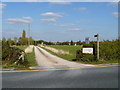
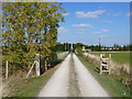
Cottage drive and footpath
Seen from Sheenhill Road, the driveway serving Holborn Cottage and Holborn Boarding Kennels is also a public footpath.
Image: © Michael Dibb
Taken: 15 Oct 2011
0.14 miles
5
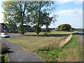
Housing by the prison
Seen from Sheenhill Road are these houses in Little Road back onto Long Lartin high security prison.
Image: © Michael Dibb
Taken: 15 Oct 2011
0.16 miles
6
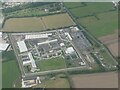
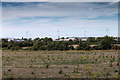
Fields next to Long Lartin Prison
Much of the area south of the road from Honeybourne to South Littleton is taken up by the prison and associated residential buildings. The prison walls can be seen on the left and the houses and living accommodation on the right.
Image: © Nigel Mykura
Taken: 9 Oct 2011
0.17 miles
7
Footpaths cross
At this point, the footpath along the drive is crossed by a footpath from Shinehill Lane to Buckle Street via Sheen Hill. Buckle Street is on the line of the Roman Road Ryknild Street.
Image: © Michael Dibb
Taken: 15 Oct 2011
0.18 miles
8
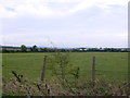
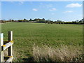
Long Lartin Prison
Distant view looking west from Sheenhill Road, towards the maximum security prison of Long Lartin.
Image: © David P Howard
Taken: 23 Aug 2016
0.20 miles
9
Towards Sheen Hill
Seen from the driveway at the point where a second footpath crosses it, is this view of the path leading to Sheen Hill and beyond to Buckle Street.
Image: © Michael Dibb
Taken: 15 Oct 2011
0.20 miles
10
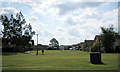
Housing Estate off Shinehill Lane
Looking south from Shinehill Lane to the housing estate built for workers at Long Lartin prison and the Unipart distribution depot.
Image: © Dave Bushell
Taken: 20 Sep 2005
0.20 miles