IMAGES TAKEN NEAR TO
Synehurst Crescent, EVESHAM, WR11 7XX
Introduction
This page details the photographs taken nearby to Synehurst Crescent, WR11 7XX by members of the Geograph project.
The Geograph project started in 2005 with the aim of publishing, organising and preserving representative images for every square kilometre of Great Britain, Ireland and the Isle of Man.

There are currently over 7.5m images from over14,400 individuals and you can help contribute to the project by visiting https://www.geograph.org.uk
Image Map
Images are licensed for reuse under creativecommons.org/licenses/by-sa/2.0
Notes
- Clicking on the map will re-center to the selected point.
- The higher the marker number, the further away the image location is from the centre of the postcode.
Image Listing (11 Images Found)
Images are licensed for reuse under creativecommons.org/licenses/by-sa/2.0
Image
Details
Distance
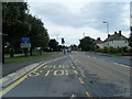
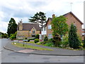
2
Manor House
The manor of Seyne dating from 1370.
Image: © David Luther Thomas
Taken: 5 May 2007
0.13 miles
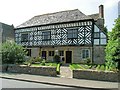
3
Shops on Badsey High St
The shops are right on the very edge of the square so that the grid line follows the line of the pavement. The shops are in SP 0643 but the road in front of them is in SP0743
Image: © Nigel Mykura
Taken: 20 Nov 2011
0.14 miles
4
Beside Badsey Brook
The footpath and Badsey Brook follow the line of trees on the right.
Image: © David Luther Thomas
Taken: 5 May 2007
0.16 miles
5
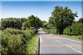
West out of Badsey on Badsey Road
The road to Evesham leaves the Badsey 30 mph zone.
Image: © David P Howard
Taken: 12 Aug 2016
0.19 miles
6
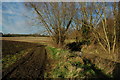
Footpath beside Badsey Brook
Badsey Brook a tributary of the River Avon can be seen on the right.
Image: © Philip Halling
Taken: 28 Dec 2009
0.19 miles
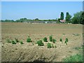
7
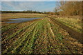
Arable land beside Badsey Brook
Badsey, is in the heart of the Vale of Evesham, and area known for market gardening though this is a field of stubble.
Image: © Philip Halling
Taken: 28 Dec 2009
0.20 miles
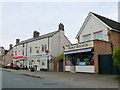
8
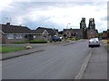
The Poplars
This short residential road populated mostly by bungalows is right on the eastern extremity of the grid square just off Badsey High St.
Image: © Nigel Mykura
Taken: 10 Jun 2011
0.20 miles
9
House on the Poplars
This house on the Poplars, a short residential road just off High St, could be in two grid squares as the zero easting line for the grid square passes right through the middle of it . The front of the house (left hand side as viewed in the image) is in this square while the rear of the house is in SP0643
Image: © Nigel Mykura
Taken: 10 Jun 2011
0.21 miles
10

Old Bridge Marker on Horsebridge, Badsey Brook
Bridge Marker set in the parapet of Horsebridge, Badsey Brook, on the south side of the B4035 Badsey Road / Bretforton Road. On the boundary of Aldington and Badsey parishes.
Milestone Society National ID: WO_ALDBAD01br
Image: © Roadside Relics
Taken: 9 Sep 2024
0.24 miles