IMAGES TAKEN NEAR TO
Gras Close, EVESHAM, WR11 7JP
Introduction
This page details the photographs taken nearby to Gras Close, WR11 7JP by members of the Geograph project.
The Geograph project started in 2005 with the aim of publishing, organising and preserving representative images for every square kilometre of Great Britain, Ireland and the Isle of Man.

There are currently over 7.5m images from over14,400 individuals and you can help contribute to the project by visiting https://www.geograph.org.uk
Image Map (Loading...)


Getting Data...Please wait
Leaflet Map data © OpenStreetMap
Images are licensed for reuse under creativecommons.org/licenses/by-sa/2.0
Notes
- Clicking on the map will re-center to the selected point.
- The higher the marker number, the further away the image location is from the centre of the postcode.
Image Listing (20 Images Found)
Images are licensed for reuse under creativecommons.org/licenses/by-sa/2.0
Image
Details
Distance
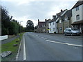
1
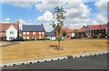
Gras Close, Bretforton
New housing around a green. I'm sure I read somewhere that Gras is a local word for asparagus, which is grown around here, but I can't find anything on the web to back this up.
Image: © Des Blenkinsopp
Taken: 24 Jul 2018
0.00 miles
2
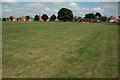
Cricket field, Bretforton
Cricket field and pavilion in Bretforton.
Image: © Philip Halling
Taken: 8 Aug 2010
0.14 miles
3
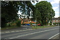
Victoria Terrace, Bretforton
Victoria Terrace viewed here through the trees is a date of 1898.
Image: © Philip Halling
Taken: 8 Aug 2010
0.14 miles
4
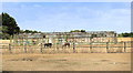
Derelict Glasshouse, Bretforton
Superseded by polytunnels, the old style glasshouses have been left going to ruin.
Image: © Des Blenkinsopp
Taken: 24 Jul 2018
0.16 miles
5
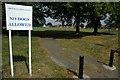
NO DOGS ALLOWED
A footpath crosses this playing field and cricket field at Bretforton.
Image: © Philip Halling
Taken: 8 Aug 2010
0.16 miles
6
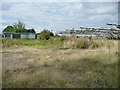
Caravan and disused polytunnels, Bretforton Road
Nothing has been cultivated here recently.
Image: © Christine Johnstone
Taken: 20 Aug 2014
0.16 miles
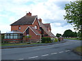
8
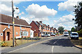
Main Street, Bretforton
A black-and-white house viewed from the Drinkwater Lane junction.
Image: © Jonathan Billinger
Taken: 23 Jun 2011
0.18 miles
10
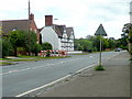
Houses on Clayfield Rd
Clayfield Rd leads out of the village to Clayfield Barn and then on to South Littleton. These red brick semi-detached house are at the junction with Station Rd.
Image: © Nigel Mykura
Taken: 10 Jun 2011
0.18 miles