IMAGES TAKEN NEAR TO
Port Street, EVESHAM, WR11 3LA
Introduction
This page details the photographs taken nearby to Port Street, WR11 3LA by members of the Geograph project.
The Geograph project started in 2005 with the aim of publishing, organising and preserving representative images for every square kilometre of Great Britain, Ireland and the Isle of Man.

There are currently over 7.5m images from over14,400 individuals and you can help contribute to the project by visiting https://www.geograph.org.uk
Image Map
Images are licensed for reuse under creativecommons.org/licenses/by-sa/2.0
Notes
- Clicking on the map will re-center to the selected point.
- The higher the marker number, the further away the image location is from the centre of the postcode.
Image Listing (580 Images Found)
Images are licensed for reuse under creativecommons.org/licenses/by-sa/2.0
Image
Details
Distance
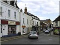
2
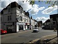
Port Street, Evesham
One of the main routes leading out of Evesham town centre, Port Street forms part of the B4035. It is seen here at the eastern end of Workman Bridge and the junction with Waterside. This area is still known as Bengeworth and was once a separate settlement from Evesham, with its own market place and a history dating back to medieval times. Today most of the buildings are 18th or 19th century and, as this view shows, Port Street remains a commercially vibrant area.
Image: © Stephen McKay
Taken: 13 Apr 2022
0.01 miles
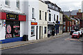
3
Angel Vaults
Public house at the corner of Castle Street and Port Street, Evesham.
Image: © David Dixon
Taken: 20 Jun 2017
0.01 miles
4
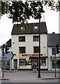
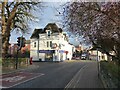
Business premises, Port Street
At the junction with Waterside.
Image: © Pauline E
Taken: 29 Aug 2010
0.01 miles
5
Port Street and the Workman Bridge
Image: © David Luther Thomas
Taken: 21 Jul 2007
0.02 miles
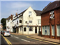
6
Junction of Port Street and Waterside, Evesham
Image: © David Gearing
Taken: 25 Apr 2017
0.02 miles
7
Road junction and estate agent office, with road sign, Evesham
Image: © Ruth Sharville
Taken: 22 Nov 2022
0.02 miles
8
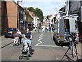
Evesham sight seeing, Sunday morning.
A view down Port Street, where the TV people had set up shop. The Workman Bridge across the Avon at the bottom is blocked off beyond the flood water as it received possible damage from debris and caravans being swept into the arches by the floods on early Saturday morning, 21st July 2007.
Image: © Jonathan Billinger
Taken: 22 Jul 2007
0.02 miles
9
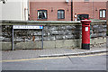
Edward VII pillar box, Mortimers Quay
At the east end of Workman Bridge.
Image: © Pauline E
Taken: 29 Aug 2010
0.03 miles
10
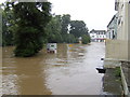
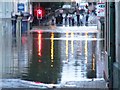
Evesham Waterside; high point of the flood of July 2007
View from the Northwick Hotel towards the traffic lights at the corner of Port Street and Bridge Street. The river should be safely over to the left beyond the trees. At this time, 12.45pm on Saturday, 21st July 2007, the flood water is at its height at about 17 feet above normal.
Compare with the scene on the street the previous afternoon; Image
Image: © Jonathan Billinger
Taken: 21 Jul 2007
0.03 miles