IMAGES TAKEN NEAR TO
Daisy Close, EVESHAM, WR11 3EJ
Introduction
This page details the photographs taken nearby to Daisy Close, WR11 3EJ by members of the Geograph project.
The Geograph project started in 2005 with the aim of publishing, organising and preserving representative images for every square kilometre of Great Britain, Ireland and the Isle of Man.

There are currently over 7.5m images from over14,400 individuals and you can help contribute to the project by visiting https://www.geograph.org.uk
Image Map (Loading...)


Getting Data...Please wait
Leaflet Map data © OpenStreetMap
Images are licensed for reuse under creativecommons.org/licenses/by-sa/2.0
Notes
- Clicking on the map will re-center to the selected point.
- The higher the marker number, the further away the image location is from the centre of the postcode.
Image Listing (22 Images Found)
Images are licensed for reuse under creativecommons.org/licenses/by-sa/2.0
Image
Details
Distance
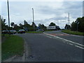
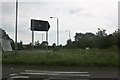
1
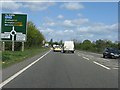
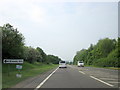
Evesham bypass - approaching the B4035 roundabout
Image: © Peter Whatley
Taken: 12 Apr 2011
0.07 miles
2
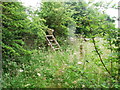
Ladder-stile, from enclosed footpath
Access to this path is officially from the A46 Evesham by-pass near the B4035 roundabout but there is no pavement along this busy road making it rather dangerous.
Image: © Liz Stone
Taken: 29 Jun 2013
0.08 miles
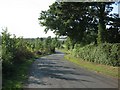
3
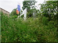
Path access from B4035
Next to development by A46 roundabout.
Image: © Liz Stone
Taken: 29 Jun 2013
0.08 miles
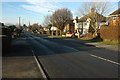
6
Knowle Hill
Looking west down Knowle Hill towards Bengeworth, glasshouses in the distance.
Image: © Dave Bushell
Taken: 12 Sep 2005
0.13 miles
7
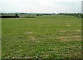
Near Ashdown Farm
Orchards beside the A46.
Image: © David Luther Thomas
Taken: 5 May 2007
0.14 miles
10
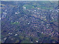
Evesham from the air
With the A46 crossing the lower half of the picture, and the big bend of the River Avon at the top.
Image: © M J Richardson
Taken: 23 Nov 2017
0.15 miles