IMAGES TAKEN NEAR TO
Leys Close, EVESHAM, WR11 2SZ
Introduction
This page details the photographs taken nearby to Leys Close, WR11 2SZ by members of the Geograph project.
The Geograph project started in 2005 with the aim of publishing, organising and preserving representative images for every square kilometre of Great Britain, Ireland and the Isle of Man.

There are currently over 7.5m images from over14,400 individuals and you can help contribute to the project by visiting https://www.geograph.org.uk
Image Map (Loading...)


Getting Data...Please wait
Leaflet Map data © OpenStreetMap
Images are licensed for reuse under creativecommons.org/licenses/by-sa/2.0
Notes
- Clicking on the map will re-center to the selected point.
- The higher the marker number, the further away the image location is from the centre of the postcode.
Image Listing (20 Images Found)
Images are licensed for reuse under creativecommons.org/licenses/by-sa/2.0
Image
Details
Distance
1
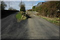
Site of Hinton Station
This was the site of Hinton Station before the Ashchurch to Evesham closed, today a trading estate occupies the site.
Image: © Philip Halling
Taken: 7 Mar 2009
0.13 miles
2
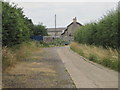
Hinton railway station (site), Worcestershire
Opened in 1864 by the Midland Railway on the "Gloucester Loop" line from Evesham to Gloucester, this station closed in 1963.
View along the approach road towards the forecourt. The railway ran left to right behind the building.
Image: © Nigel Thompson
Taken: 27 Jul 2013
0.18 miles
3
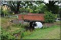
Bridge over the River Isbourne
Bridge over the River Isbourne at Hinton in the Green.
Image: © Philip Halling
Taken: 17 Jul 2011
0.19 miles
4
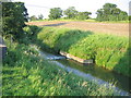
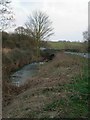
Gauging weir in the River Isbourne
Just south of Downrip Farm.
Image: © David Stowell
Taken: 17 Jun 2006
0.19 miles
6
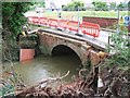
Upstream side of the bridge
This is the upstream side of the bridge over the River Isbourne at Hinton on the Green after the floods caused by the heavy rain on Friday 20th July 2007.
Image: © David Luther Thomas
Taken: 25 Jul 2007
0.20 miles
7
The downstream side of the bridge
This is the remains of the bridge over the River Isbourne following the floods caused by the heavy rain on Friday 20th July 2007. The bridge parapet has been washed away, part of it can be seen in the river.
Image: © David Luther Thomas
Taken: 25 Jul 2007
0.21 miles
8
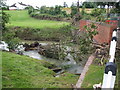
Valley of the River Isbourne, Hinton on the Green
The bridge across the river is closed following the floods caused by the heavy rain on Friday 20th July 2007.
Image: © David Luther Thomas
Taken: 25 Jul 2007
0.21 miles
9
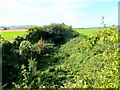
Old railway cutting
The Evesham to Ashchurch and Tewkesbury railway bed viewed looking south-west from the bridge west of Hinton on the Green.
Image: © Jonathan Billinger
Taken: 9 Sep 2009
0.21 miles
10
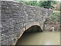
Upstream bridge face
Damage can be seen to some of the stones near the crown of the arch. Many of the capping stones along the parapet have been washed away. Resulting from the floods caused by the heavy rain on Friday 20th July 2007.
Image: © David Luther Thomas
Taken: 25 Jul 2007
0.22 miles