IMAGES TAKEN NEAR TO
Pershore Road, EVESHAM, WR11 2RB
Introduction
This page details the photographs taken nearby to Pershore Road, WR11 2RB by members of the Geograph project.
The Geograph project started in 2005 with the aim of publishing, organising and preserving representative images for every square kilometre of Great Britain, Ireland and the Isle of Man.

There are currently over 7.5m images from over14,400 individuals and you can help contribute to the project by visiting https://www.geograph.org.uk
Image Map (Loading...)


Getting Data...Please wait
Leaflet Map data © OpenStreetMap
Images are licensed for reuse under creativecommons.org/licenses/by-sa/2.0
Notes
- Clicking on the map will re-center to the selected point.
- The higher the marker number, the further away the image location is from the centre of the postcode.
Image Listing (4 Images Found)
Images are licensed for reuse under creativecommons.org/licenses/by-sa/2.0
Image
Details
Distance
1
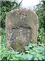
Old Milestone by the B4084, west of Lower Haselore, Cropthorne Parish
Stone post (plate lost) by the B4084 (was A44), in parish of CROPTHORNE (WYCHAVON District), West of Lower Haselor, by the road. Erected by the Evesham Second District turnpike trust in the 19th century.
Inscription reads:- : Evesham 2¾ : : Pershore / 4 :
Carved benchmark and rivet above recess.
Milestone Society National ID: WO_EVWO02.
Image: © D Beacham
Taken: 7 Jan 2014
0.19 miles
2
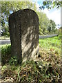
Old Milestone by B4084 (was A44), west of Lower Haselor
The Milestone is located by the road on the south side of the road. Parish of Cropthorne (Wychavon District). Stone post (plate lost), erected by the Evesham Second District turnpike trust in the 19th Century. An earlier photograph can be found here: https://www.geograph.org.uk/photo/6044383
Inscription reads:-
Evesham 2¾ : : Pershore / 4
Carved benchmark and rivet above recess.
Milestone Society National ID: WO_EVWO02
Image: © Roadside Relics
Taken: 28 Sep 2022
0.19 miles
3
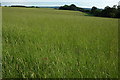
Field near Haselor Farm
View to the south across a field near Haselor Farm towards Bredon Hill.
Image: © Philip Halling
Taken: 3 Jul 2010
0.23 miles
4
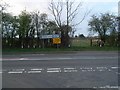
The Northern end of Haselor Lane
The junction with the B4084 (previously the A44). One of several "alternative routes" to the blossom trail starts at this junction. A footpath leads straight on towards Boston Farm and on to Charlton.
Image: © David Luther Thomas
Taken: 25 Mar 2007
0.23 miles