IMAGES TAKEN NEAR TO
Pershore Road, EVESHAM, WR11 2NA
Introduction
This page details the photographs taken nearby to Pershore Road, WR11 2NA by members of the Geograph project.
The Geograph project started in 2005 with the aim of publishing, organising and preserving representative images for every square kilometre of Great Britain, Ireland and the Isle of Man.

There are currently over 7.5m images from over14,400 individuals and you can help contribute to the project by visiting https://www.geograph.org.uk
Image Map (Loading...)


Getting Data...Please wait
Leaflet Map data © OpenStreetMap
Images are licensed for reuse under creativecommons.org/licenses/by-sa/2.0
Notes
- Clicking on the map will re-center to the selected point.
- The higher the marker number, the further away the image location is from the centre of the postcode.
Image Listing (45 Images Found)
Images are licensed for reuse under creativecommons.org/licenses/by-sa/2.0
Image
Details
Distance
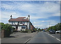
3
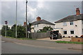
The Cider Mill, Hampton
The Cider Mill is a traditional pub serving the community of Hampton, an Evesham suburb. The clouds above are threatening rain on a day of sunshine and showers.
Image: © Stephen McKay
Taken: 13 Apr 2022
0.02 miles
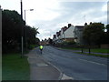
4
B4084 approaches junction with School Road
At these traffic lights School Road is on the left and Peewit Road on the right.
Image: © Stuart Logan
Taken: 12 May 2013
0.04 miles
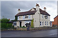
7
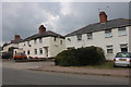
Houses on Pershore Road
Terrace houses on the B4084 Pershore Road in Evesham.
Image: © Philip Halling
Taken: 4 Apr 2021
0.09 miles
8
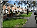
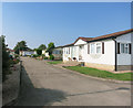
Footpath through the housing
A public footpath runs through the middle of this estate.
The map calls it a mobile home park, but I doubt these places are going anywhere much.
Image: © Des Blenkinsopp
Taken: 14 Sep 2016
0.11 miles
9
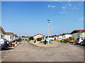
Bungalows at Hampton
Part of a sizeable low-rise estate which the map calls a mobile home park.
Maybe that's what it was originally, but these places aren't going anywhere in a hurry.
Image: © Des Blenkinsopp
Taken: 14 Sep 2016
0.14 miles
10
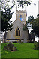
Hampton Church
St Andrew's Church dates from the 12th century and was restored in 1903 by C F Whitcombe. It is grade II* listed. The clock on the tower is telling approximately the correct time.
Image: © Stephen McKay
Taken: 13 Apr 2022
0.15 miles