IMAGES TAKEN NEAR TO
Tilesford, PERSHORE, WR10 2LA
Introduction
This page details the photographs taken nearby to WR10 2LA by members of the Geograph project.
The Geograph project started in 2005 with the aim of publishing, organising and preserving representative images for every square kilometre of Great Britain, Ireland and the Isle of Man.

There are currently over 7.5m images from over14,400 individuals and you can help contribute to the project by visiting https://www.geograph.org.uk
Image Map (Loading...)


Getting Data...Please wait
Leaflet Map data © OpenStreetMap
Images are licensed for reuse under creativecommons.org/licenses/by-sa/2.0
Notes
- Clicking on the map will re-center to the selected point.
- The higher the marker number, the further away the image location is from the centre of the postcode.
Image Listing (5 Images Found)
Images are licensed for reuse under creativecommons.org/licenses/by-sa/2.0
Image
Details
Distance
1
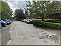
Tilesford Park
I can't be certain because the very old (2005) photo https://www.geograph.org.uk/photo/50283 doesn't give a precise location but I suspect it is the same as my photo above. Now known as Tilesford Park, the old MOD housing as shown in 2005, seems to have been demolished and replaced with new housing and a residential care home for the elderly. See also https://www.geograph.org.uk/photo/7884071.
Image: © Mike Dodman
Taken: 27 Sep 2024
0.13 miles
2
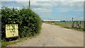
Entrance to Rotherdale Farm
Posh autumatic gates by Long Lane for this large modern farming business.
Image: © Jonathan Billinger
Taken: 24 Jun 2014
0.13 miles
3
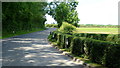
Long Lane
Bendy section at Tilesford.
Image: © Jonathan Billinger
Taken: 24 Jun 2014
0.14 miles
4
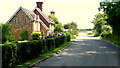
Tilesford Cottages
Adjacent to Long Lane, looking east towards Throckmorton Airfield.
Image: © Jonathan Billinger
Taken: 24 Jun 2014
0.21 miles
5
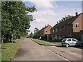
Tilesford
Former MOD housing estate at Tilesford, used by workers at Pershore Airfield and now sold off for private use.
Image: © Dave Bushell
Taken: 7 Sep 2005
0.23 miles