IMAGES TAKEN NEAR TO
Long Lane, PERSHORE, WR10 2JH
Introduction
This page details the photographs taken nearby to Long Lane, WR10 2JH by members of the Geograph project.
The Geograph project started in 2005 with the aim of publishing, organising and preserving representative images for every square kilometre of Great Britain, Ireland and the Isle of Man.

There are currently over 7.5m images from over14,400 individuals and you can help contribute to the project by visiting https://www.geograph.org.uk
Image Map
Images are licensed for reuse under creativecommons.org/licenses/by-sa/2.0
Notes
- Clicking on the map will re-center to the selected point.
- The higher the marker number, the further away the image location is from the centre of the postcode.
Image Listing (7 Images Found)
Images are licensed for reuse under creativecommons.org/licenses/by-sa/2.0
Image
Details
Distance
1
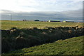
Pershore Airfield
Pershore Airfield closed to aircraft in 1978, today the hangars are used by businesses.
Image: © Philip Halling
Taken: 22 Dec 2008
0.08 miles
2
Control Tower at Pershore Airfield
The former Control Tower and hangar at Pershore Airfield. The airfield opened in June 1934 and until the outbreak of World War II it was home to the Worcestershire Flying School with Tiger Moths. Soon after the outbreak of the war the airfield was requisitioned. From April 1941 to March 1944, the airfield was used by the Operational Training Unit to train Canadian crews with Wellingtons. During the war the airfield was attacked three times by the Luftwaffe. From 1957 to 1978, the site was used by the Royal Radar Establishment. Today the airfield is disused, however, the site is used by a number of businesses.
Image: © Philip Halling
Taken: 22 Dec 2008
0.13 miles
3
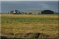
Pershore Airfield at dusk
Former airfield seen from Long Lane near Throckmorton.
Image: © Chris Allen
Taken: 17 Jan 2015
0.21 miles
4
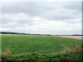
Disused airfield at Throckmorton from Long Lane
Image: © Roy Hughes
Taken: 28 Aug 2021
0.21 miles
5
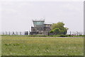
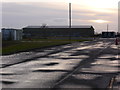
Disused Control Tower, Pershore airfield
1934-1939 Pershore was home to the Worcestershire flying school flying Tiger Moths, at the start of WW2 it was requisitioned, 1941-1944 Operational training unit for Royal Canadian Air Force flying Wellingtons, after the war it became the flying unit for the radar research establishment and recently has become the burial ground for thousands of animals after the 2001 foot & mouth outbreak.
Image: © Richard Dunn
Taken: 17 May 2005
0.22 miles
6
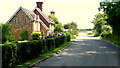
Tilesford Cottages
Adjacent to Long Lane, looking east towards Throckmorton Airfield.
Image: © Jonathan Billinger
Taken: 24 Jun 2014
0.23 miles
7
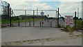
Throckmorton Airfield
Used for many things except maybe flying?
Image: © Jonathan Billinger
Taken: 24 Jun 2014
0.23 miles