IMAGES TAKEN NEAR TO
Station Road, PERSHORE, WR10 2BX
Introduction
This page details the photographs taken nearby to Station Road, WR10 2BX by members of the Geograph project.
The Geograph project started in 2005 with the aim of publishing, organising and preserving representative images for every square kilometre of Great Britain, Ireland and the Isle of Man.

There are currently over 7.5m images from over14,400 individuals and you can help contribute to the project by visiting https://www.geograph.org.uk
Image Map (Loading...)


Getting Data...Please wait
Leaflet Map data © OpenStreetMap
Images are licensed for reuse under creativecommons.org/licenses/by-sa/2.0
Notes
- Clicking on the map will re-center to the selected point.
- The higher the marker number, the further away the image location is from the centre of the postcode.
Image Listing (26 Images Found)
Images are licensed for reuse under creativecommons.org/licenses/by-sa/2.0
Image
Details
Distance
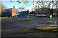
1
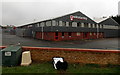
Pershore High School
On the east side of Station Road, in the north of Pershore.
Image: © Jaggery
Taken: 16 Nov 2014
0.05 miles
2
Pershore High School
Pershore High School is situated between Pershore and the village of Pinvin.
Image: © Philip Halling
Taken: 23 Nov 2008
0.05 miles
3
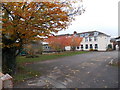
Late autumn colours, Pershore High School
The southern edge of Pershore High School viewed from Station Road in mid November 2014.
Image: © Jaggery
Taken: 16 Nov 2014
0.07 miles
4
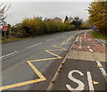
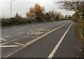
Zigzag road markings outside Pershore High School
The markings at the edge of the A4104 Station Road delimit a Keep Clear zone near a school entrance.
Image: © Jaggery
Taken: 16 Nov 2014
0.08 miles
5
Pershore High School bus stops
Alongside the A4104 Station Road in the north of Pershore.
Image: © Jaggery
Taken: 16 Nov 2014
0.08 miles
6
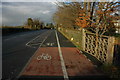
Cycle path and footpath past Pershore High School
Cycle path and footpath along side the A4104, Station Road, past Pershore High School.
Image: © Philip Halling
Taken: 23 Nov 2008
0.08 miles
7
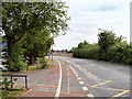
Station Road, Pershore
The A4104 passing Pershore High School
Image: © David Dixon
Taken: 26 Jun 2017
0.08 miles
8
Obsolete council notice, Pershore
On the east side of Station Road, viewed in November 2014. The fading notice was issued by the County Council of Hereford and Worcester, which was created on April 1st 1974 following the Local Government Act 1972.
The new county included the former administrative county of Herefordshire and most of Worcestershire (except Halesowen, Stourbridge and Warley, which became part of the West Midlands, and the County Borough of Worcester).
The intention was to increase local government efficiency, since the two counties were among England's smaller and least populous counties, particularly after the same act moved some of Worcestershire's most urbanised areas to the West Midlands. Predictably, it aroused much resentment and opposition in Herefordshire, which regarded it as a takeover by Worcestershire.
The County Council of Hereford and Worcester was abolished in 1998 and reverted, with some border adjustments, to the two separate historic counties of Herefordshire and Worcestershire.
Image: © Jaggery
Taken: 16 Nov 2014
0.12 miles
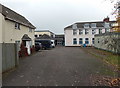
9
Winstanley, Pershore
Fabrication specialists on the south side of Racecourse Road, viewed from Station Road.
Image: © Jaggery
Taken: 16 Nov 2014
0.14 miles
10
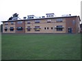
The Philip Richardson Science Building
New science labs at Pershore High School opened by the chairman of the Governors, Philip Richardson, on 22 September 2005
Image: © Bob Embleton
Taken: 22 Sep 2005
0.15 miles