IMAGES TAKEN NEAR TO
Station Road, PERSHORE, WR10 2BT
Introduction
This page details the photographs taken nearby to Station Road, WR10 2BT by members of the Geograph project.
The Geograph project started in 2005 with the aim of publishing, organising and preserving representative images for every square kilometre of Great Britain, Ireland and the Isle of Man.

There are currently over 7.5m images from over14,400 individuals and you can help contribute to the project by visiting https://www.geograph.org.uk
Image Map (35 Images)


Getting Data...Please wait
Leaflet Map data © OpenStreetMap
Images are licensed for reuse under creativecommons.org/licenses/by-sa/2.0
Notes
- Clicking on the map will re-center to the selected point.
- The higher the marker number, the further away the image location is from the centre of the postcode.
Image Listing (35 Images Found)
Images are licensed for reuse under creativecommons.org/licenses/by-sa/2.0
Image
Details
Distance
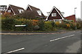
1
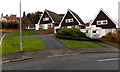
Three triangular roofs in suburban Pershore
Located on the corner of Acorn Grove and Ashdale Avenue are three of many houses
hereabouts with prominent roofs. Pershore Hall http://www.geograph.org.uk/photo/46947 is in the background.
Image: © Jaggery
Taken: 16 Nov 2014
0.05 miles
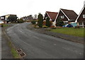
2
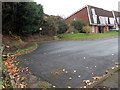
Acorn Grove from the south, Pershore
Looking north from this turning area. http://www.geograph.org.uk/photo/4252955
Image: © Jaggery
Taken: 16 Nov 2014
0.05 miles
3
Acorn Grove, Pershore
Viewed from Ashdale Avenue.
Image: © Jaggery
Taken: 16 Nov 2014
0.07 miles
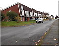
4
Houses on the west side of Ashdale Avenue, Pershore
North of the Acorn Grove junction.
Image: © Jaggery
Taken: 16 Nov 2014
0.08 miles
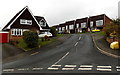
5
Corner of Beechcombe Close and Ashdale Avenue, Pershore
Part of an area of houses on the west side of Station Road.
Image: © Jaggery
Taken: 16 Nov 2014
0.08 miles
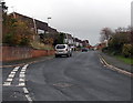
6
Ashdale Avenue, Pershore
From the corner of Station Road.
Image: © Jaggery
Taken: 16 Nov 2014
0.09 miles
7
Ashdale Avenue north of Acorn Grove, Pershore
Viewed from this http://www.geograph.org.uk/photo/4252926 junction.
Image: © Jaggery
Taken: 16 Nov 2014
0.10 miles
8
Birchtree Grove, Pershore
Short cul-de-sac on the south side of Ashdale Avenue.
Image: © Jaggery
Taken: 16 Nov 2014
0.11 miles
9
Turning area at the southern end of Acorn Grove, Pershore
A Worcestershire County Council notice shows Turning area. No parking.
Image: © Jaggery
Taken: 16 Nov 2014
0.11 miles
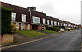
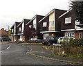
10
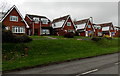
Station Road houses, Pershore
Set above the west side of Station Road, viewed from the corner of Apple Tree Road.
Image: © Jaggery
Taken: 16 Nov 2014
0.11 miles