IMAGES TAKEN NEAR TO
Farleigh Road, PERSHORE, WR10 1LY
Introduction
This page details the photographs taken nearby to Farleigh Road, WR10 1LY by members of the Geograph project.
The Geograph project started in 2005 with the aim of publishing, organising and preserving representative images for every square kilometre of Great Britain, Ireland and the Isle of Man.

There are currently over 7.5m images from over14,400 individuals and you can help contribute to the project by visiting https://www.geograph.org.uk
Image Map
Images are licensed for reuse under creativecommons.org/licenses/by-sa/2.0
Notes
- Clicking on the map will re-center to the selected point.
- The higher the marker number, the further away the image location is from the centre of the postcode.
Image Listing (25 Images Found)
Images are licensed for reuse under creativecommons.org/licenses/by-sa/2.0
Image
Details
Distance
1
Entrance to Birlingham Close
Looking south-east along the B4536. Birlingham close runs parallel and close to the main road and can be seen on the left.
Image: © Trevor Rickard
Taken: 1 Dec 2008
0.05 miles
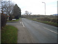
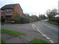
2
Defford Road
Running along the southern boundary of Pershore. Looking west to Tiddesley Wood on the hill.
Image: © Trevor Rickard
Taken: 1 Dec 2008
0.09 miles
3
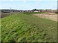
Pershore flood defence
Pershore flood defence or bund running alongside Defford Road. This flood defence was constructed around 2011, a responds to the devastating floods of July 2007.
Image: © Philip Halling
Taken: 30 Jan 2022
0.09 miles
4
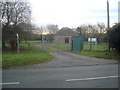
Pumping station on Defford Road
Small Severn Trent site on the south side of the road.
Image: © Trevor Rickard
Taken: 1 Dec 2008
0.12 miles
5
Housing estate off the B4536
Large modern estates to the left of the B4536 Defford Road, which is the town boundary to the south. Although most of the Avon flood plain is to the right, this is another example of a housing estate partly built on flood plain land. The houses off Defford Road have been flooded and a half-million pound barrier is now being proposed. Turning to Cornmore to the left.
http://www.worcesternews.co.uk/news/local/3879050.Pershore_in_line_for___500_000_flood_barrier/
Image: © Trevor Rickard
Taken: 1 Dec 2008
0.12 miles
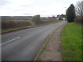
6
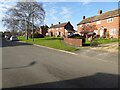
Houses on Farleigh Road
Houses, probably built in the 1950s, on Farleigh Road in Pershore.
Image: © Philip Halling
Taken: 30 Jan 2022
0.17 miles
7
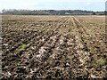
Arable farmland beside the River Avon
Arable farmland beside the River Avon at Pershore.
Image: © Philip Halling
Taken: 30 Jan 2022
0.19 miles
8
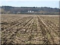
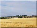
View to Tiddesley Wood
View to houses in front of Tiddesley Wood, viewed across arable farmland on the Avon floodplain.
Image: © Philip Halling
Taken: 30 Jan 2022
0.19 miles
9

Narcissus on New Year's Eve
Narcissus in bloom beside Defford Road in Pershore on New Year's Eve.
Image: © Philip Halling
Taken: 31 Dec 2015
0.20 miles
10
Towards Pershore Cemetery from the Millennium Way
On the banks of the River Avon.
Image: © Jeff Gogarty
Taken: 18 Aug 2022
0.20 miles