IMAGES TAKEN NEAR TO
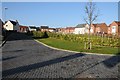
Woodward Close, PERSHORE, WR10 1LP
Introduction
This page details the photographs taken nearby to Woodward Close, WR10 1LP by members of the Geograph project.
The Geograph project started in 2005 with the aim of publishing, organising and preserving representative images for every square kilometre of Great Britain, Ireland and the Isle of Man.

There are currently over 7.5m images from over14,400 individuals and you can help contribute to the project by visiting https://www.geograph.org.uk
Image Map
Images are licensed for reuse under creativecommons.org/licenses/by-sa/2.0
Notes
- Clicking on the map will re-center to the selected point.
- The higher the marker number, the further away the image location is from the centre of the postcode.
Image Listing (36 Images Found)
Images are licensed for reuse under creativecommons.org/licenses/by-sa/2.0
Image
Details
Distance
1
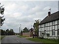
Old house and new housing, Three Springs Road, Pershore
Image: © David Smith
Taken: 8 Oct 2016
0.12 miles
2
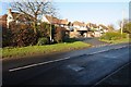
Houses on Three Springs Road, Pershore
Image: © Philip Halling
Taken: 28 Dec 2014
0.14 miles
3
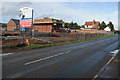
Building development, Pershore
Building development by the builders, Bellway on Three Springs Road in Pershore.
Image: © Philip Halling
Taken: 25 Sep 2011
0.15 miles
4
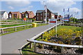
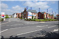
Bloor Homes and Bellway houses
Bloor Homes and Bellway housing development off Three Springs Road in Pershore.
Image: © Philip Halling
Taken: 19 May 2013
0.16 miles
5

Housing development on Three Springs Road
Banners flying promoting the Bloor Homes housing development on Three Springs Road in Pershore.
Image: © Philip Halling
Taken: 28 Dec 2014
0.16 miles
6
Desjardins Way, Pershore
A new housing development off Three Springs Road. The houses were built by Bloor Homes.
Image: © Philip Halling
Taken: 28 Dec 2014
0.16 miles
7
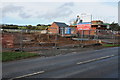
Building development, Pershore
Building development by builders, Bellway on Three Springs Road in Pershore.
Image: © Philip Halling
Taken: 25 Sep 2011
0.16 miles
8
New housing estate
New Bellway homes at a housing development on Three Springs Road in Pershore.
Image: © Philip Halling
Taken: 19 May 2013
0.16 miles
9
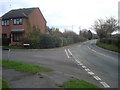
Housing estate off the B4536
Large modern estates to the left of the B4536 Defford Road, which is the town boundary to the south. Although most of the Avon flood plain is to the right, this is another example of a housing estate partly built on flood plain land. The houses off Defford Road have been flooded and a half-million pound barrier is now being proposed. Turning to Cornmore to the left.
http://www.worcesternews.co.uk/news/local/3879050.Pershore_in_line_for___500_000_flood_barrier/
Image: © Trevor Rickard
Taken: 1 Dec 2008
0.17 miles
10
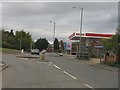
Esso filling station on Three Springs Road
Image: © Peter Whatley
Taken: 12 Oct 2011
0.17 miles