IMAGES TAKEN NEAR TO
Westcott Way, WR10 1FN
Introduction
This page details the photographs taken nearby to Westcott Way, WR10 1FN by members of the Geograph project.
The Geograph project started in 2005 with the aim of publishing, organising and preserving representative images for every square kilometre of Great Britain, Ireland and the Isle of Man.

There are currently over 7.5m images from over14,400 individuals and you can help contribute to the project by visiting https://www.geograph.org.uk
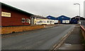
Image Map (Loading...)


Getting Data...Please wait
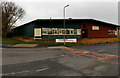
Leaflet Map data © OpenStreetMap
Images are licensed for reuse under creativecommons.org/licenses/by-sa/2.0
Notes
- Clicking on the map will re-center to the selected point.
- The higher the marker number, the further away the image location is from the centre of the postcode.
Image Listing (57 Images Found)
Images are licensed for reuse under creativecommons.org/licenses/by-sa/2.0
Image
Details
Distance
1
Chase Heating, Pershore
Viewed from Station Road. Stoves and cookers are on sale at this Racecourse Road showroom and warehouse.
Image: © Jaggery
Taken: 16 Nov 2014
0.09 miles
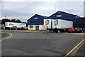
2
Winstanley, Pershore
Fabrication specialists on the south side of Racecourse Road, viewed from Station Road.
Image: © Jaggery
Taken: 16 Nov 2014
0.10 miles
3
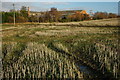
Arable land near Pershore
View across arable land from a footpath to induistrial buildings near Pershore railway station.
Image: © Philip Halling
Taken: 23 Nov 2008
0.11 miles
4
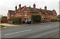
Coventry Terrace, Pershore
Row of houses built on the west side of Station Road in the mid 1880s.
Image: © Jaggery
Taken: 16 Nov 2014
0.11 miles
5
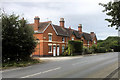
Coventry Terrace, Station Road, Pershore
A row of houses near Pershore Station.
Image: © David Dixon
Taken: 26 Jun 2017
0.12 miles
6
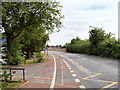
Station Road, Pershore
The A4104 passing Pershore High School
Image: © David Dixon
Taken: 26 Jun 2017
0.12 miles
7
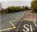
Zigzag road markings outside Pershore High School
The markings at the edge of the A4104 Station Road delimit a Keep Clear zone near a school entrance.
Image: © Jaggery
Taken: 16 Nov 2014
0.13 miles
8
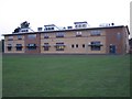
The Philip Richardson Science Building
New science labs at Pershore High School opened by the chairman of the Governors, Philip Richardson, on 22 September 2005
Image: © Bob Embleton
Taken: 22 Sep 2005
0.14 miles
9
SW end of Racecourse Road, Pershore
Viewed from Station Road. Racecourse Road leads to Pershore Trading Estate and a business park. Chase Heating http://www.geograph.org.uk/photo/4259578 is on the left.
Image: © Jaggery
Taken: 16 Nov 2014
0.15 miles
10
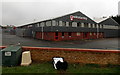
Racecourse Road Trading Estate Pershore
Image: © David Dixon
Taken: 26 Jun 2017
0.15 miles