IMAGES TAKEN NEAR TO
Hutton Road, SKELMERSDALE, WN8 8HS
Introduction
This page details the photographs taken nearby to Hutton Road, WN8 8HS by members of the Geograph project.
The Geograph project started in 2005 with the aim of publishing, organising and preserving representative images for every square kilometre of Great Britain, Ireland and the Isle of Man.

There are currently over 7.5m images from over14,400 individuals and you can help contribute to the project by visiting https://www.geograph.org.uk
Image Map
Images are licensed for reuse under creativecommons.org/licenses/by-sa/2.0
Notes
- Clicking on the map will re-center to the selected point.
- The higher the marker number, the further away the image location is from the centre of the postcode.
Image Listing (11 Images Found)
Images are licensed for reuse under creativecommons.org/licenses/by-sa/2.0
Image
Details
Distance
1

War Memorial, Old Skelmersdale
Situated near the Victoria Hotel at the bottom of Sandy Lane, Old Skelmersdale
Image: © Sue Adair
Taken: 15 Oct 2005
0.05 miles
2

The Market Gate at Sandy Lane Centre
Image: © Raymond Knapman
Taken: 22 Sep 2010
0.10 miles
3
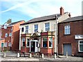
The Victoria Hotel in old Skelmersdale
Image: © Raymond Knapman
Taken: 22 Sep 2010
0.11 miles
4
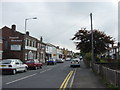
Sandy Lane, Old Skelmersdale
Shops and businesses in Sandy Lane, Old Skelmersdale, to the east of Ormskirk, an old coal mining village that became a New Town in the 1960s. 'Skem', as its locally called, was mentioned in the Domesday Book has a very long and interesting history. Dating back to 55 BC the Town was used as a resting place for Roman soldiers marching from Wigan to the harbour at Crosby on the River Mersey. Some 20 years ago a great quantity of Roman coins was discovered buried at Ottershead Farm. Skelmersdale lies in the shadow of Ashurst Beacon, where the District Council have created Beacon Country Park.
Image: © Sue Adair
Taken: 15 Oct 2005
0.13 miles

8
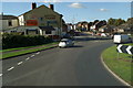
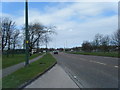
The end of Ormskirk Road, Skelmersdale
As seen from the top deck of the 375 Wigan - Southport bus.
Image: © David Long
Taken: 16 Oct 2009
0.20 miles

10
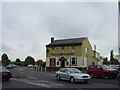
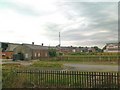
The Railway Tavern, Blaguegate
Railway Tavern on the corner of Ormskirk Road and Railway Road, Blaguegate where there was once a railway line to Ormskirk and St Helens. (See http://www.disused-stations.org.uk/s/skelmersdale/index.shtml for information.) Commencing around 1850 and in the course of some 75 years, Skelmersdale became a fast growing mining town and the population grew 8 times as miners came from other parts of the country to exploit the coal reserves. Over this period there were at least 50 coal mines and around 1918 there were some 2,000 people working in local mines. Water was a perennial problem with mines in the area, many having been sunk through the moss lands to reach profitable seams, and this indirectly led to the catastrophic decline of the coal industry in Skelmersdale. Industrial relations were not good in the latter part of the 19th Century and there were several strikes, during which time conditions underground deteriorated as it was often many weeks before a mine could begin production again. The real “coup-de-grace” of the industry was the National Coal Strike of 1926, which resulted in severe flooding of the unattended workings and led to the closure of most of the remaining pits. Thus ended a major epoch in the growth of Skelmersdale, and it is sad to say that the New Town has been built with no acknowledgement of the town’s mining past.
Image: © Sue Adair
Taken: 15 Oct 2005
0.24 miles