IMAGES TAKEN NEAR TO
Hand Lane, LEIGH, WN7 3NA
Introduction
This page details the photographs taken nearby to Hand Lane, WN7 3NA by members of the Geograph project.
The Geograph project started in 2005 with the aim of publishing, organising and preserving representative images for every square kilometre of Great Britain, Ireland and the Isle of Man.

There are currently over 7.5m images from over14,400 individuals and you can help contribute to the project by visiting https://www.geograph.org.uk
Image Map (Loading...)


Getting Data...Please wait
Leaflet Map data © OpenStreetMap
Images are licensed for reuse under creativecommons.org/licenses/by-sa/2.0
Notes
- Clicking on the map will re-center to the selected point.
- The higher the marker number, the further away the image location is from the centre of the postcode.
Image Listing (9 Images Found)
Images are licensed for reuse under creativecommons.org/licenses/by-sa/2.0
Image
Details
Distance
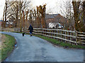
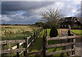
4
Bowling Green, Hand Lane, Pennington
Image: © Anthony Parkes
Taken: 20 Jun 2010
0.15 miles
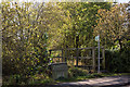
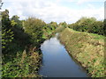
5
The Glazebrook Trail eastwards
Probably not recommended on a hot sunny day, it's headed towards a sewage works
Image: © Ian Greig
Taken: 7 Oct 2011
0.16 miles
6
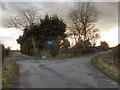
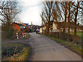
Hand Lane-Carr Lane Junction
The sign indicates that both branches of the fork lead to dead ends.
Image: © David Dixon
Taken: 18 Feb 2012
0.21 miles
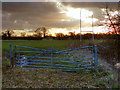
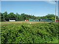
9
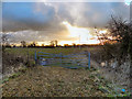
Rugby Pitch
The rugby pitch behind Carr Lane.
Image: © David Dixon
Taken: 18 Feb 2012
0.25 miles