IMAGES TAKEN NEAR TO
Hope Carr Road, LEIGH, WN7 3ET
Introduction
This page details the photographs taken nearby to Hope Carr Road, WN7 3ET by members of the Geograph project.
The Geograph project started in 2005 with the aim of publishing, organising and preserving representative images for every square kilometre of Great Britain, Ireland and the Isle of Man.

There are currently over 7.5m images from over14,400 individuals and you can help contribute to the project by visiting https://www.geograph.org.uk
Image Map
Images are licensed for reuse under creativecommons.org/licenses/by-sa/2.0
Notes
- Clicking on the map will re-center to the selected point.
- The higher the marker number, the further away the image location is from the centre of the postcode.
Image Listing (41 Images Found)
Images are licensed for reuse under creativecommons.org/licenses/by-sa/2.0
Image
Details
Distance
1
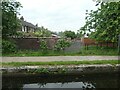
Back lane between Henry Street and Edward Street
Canalside houses off East Bridgewater Street, Leigh. Built between 1905 and 1925.
Image: © Christine Johnstone
Taken: 29 May 2021
0.16 miles
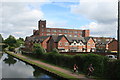
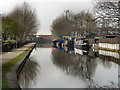
2
Bridgewater Canal
Looking east along the Bridgewater Canal from Bedford Basin. Image] and Image] are prominent in the background.
Image: © David Dixon
Taken: 24 Mar 2011
0.18 miles
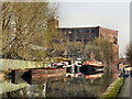
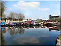
3
Bridgewater Canal, Leigh
Barges moored near to Bedford Basin on the Bridgewater Canal, in Leigh.
Image: © David Dixon
Taken: 24 Mar 2011
0.18 miles
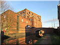
4
Brooklands Mill, Leigh
A five storey spinning mill by the Bridgewater Canal and built in 1893 with a 1200 horsepower J & E Wood mill engine. Now in multiple occupancy. The chimney has been demolished.
Image: © Chris Allen
Taken: 25 Jun 2016
0.19 miles
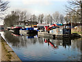
5
Bridgewater Canal, Leigh
Looking west along the towpath of the Bridgewater Canal, from close to Mather Lane Bridge.
Image: © David Dixon
Taken: 24 Mar 2011
0.19 miles
7
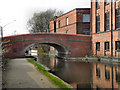
Bridgewater Canal, Mather Lane Bridge
The Bridge at Mather Lane. To the right of the bridge is the Mather Lane Mill.
Image: © David Dixon
Taken: 24 Mar 2011
0.19 miles
8
Bridgewater Canal, Leigh
Close to Bedford Basin.
Image: © David Dixon
Taken: 24 Mar 2011
0.19 miles
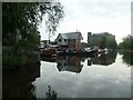
9
Bridgewater Canal, Bedford Basin
Bedford Basin, in Leigh.
Image: © David Dixon
Taken: 24 Mar 2011
0.20 miles
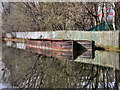
10
Bedford basin, Bridgewater canal, Leigh
Bedford basin was created between 1845 and 1890. Coal was transhipped onto barges here, from a mineral line running south from Atherton collieries.
Image: © Christine Johnstone
Taken: 29 May 2021
0.20 miles