IMAGES TAKEN NEAR TO
Warrington Road, LEIGH, WN7 3EA
Introduction
This page details the photographs taken nearby to Warrington Road, WN7 3EA by members of the Geograph project.
The Geograph project started in 2005 with the aim of publishing, organising and preserving representative images for every square kilometre of Great Britain, Ireland and the Isle of Man.

There are currently over 7.5m images from over14,400 individuals and you can help contribute to the project by visiting https://www.geograph.org.uk
Image Map
Images are licensed for reuse under creativecommons.org/licenses/by-sa/2.0
Notes
- Clicking on the map will re-center to the selected point.
- The higher the marker number, the further away the image location is from the centre of the postcode.
Image Listing (42 Images Found)
Images are licensed for reuse under creativecommons.org/licenses/by-sa/2.0
Image
Details
Distance
1
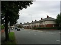
Warrington Road, Leigh.
Looking south down Warrington Road, Leigh near its junction with Hope Carr Road. Typical housing for this part of Leigh. SJ 66919792.
Image: © Keith Williamson
Taken: 11 Sep 2005
0.11 miles
2
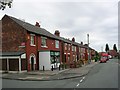
Hooten Lane
Looking south down Hooten Lane, Leigh, near its junction with Highfield Avenue. Typical of the older housing stock in this area of Leigh. SJ67169934.
Image: © Keith Williamson
Taken: 11 Sep 2005
0.11 miles
3
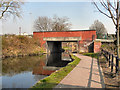
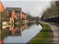
Bridgewater Canal, Butts Bridge
The bridge carrying Warrington Road (A574) over The Bridgewater Canal, at Leigh.
Image: © David Dixon
Taken: 24 Mar 2011
0.16 miles
4
Butt's Bridge [no 64], from the west
Carrying the Warrington Road over the Bridgewater canal.
Image: © Christine Johnstone
Taken: 29 May 2021
0.16 miles
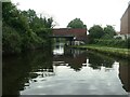
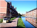
5
Bridgewater Canal, Leigh
Looking east along the towpath of the Bridgewater Canal, near to the Warrington Road Bridge, at Leigh.
Image: © David Dixon
Taken: 24 Mar 2011
0.17 miles
6
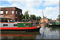
Bridgewater Canal, Leigh
Looking into some moorings in a small basin in the Bedford area of Leigh.
Image: © Chris Allen
Taken: 25 Jun 2016
0.17 miles
7
New housing on the Leeds Liverpool Leigh Branch Canal
The housing occupy the site of Pendle Mills at Butts Bridge
Image: © Raymond Knapman
Taken: 4 Oct 2010
0.17 miles
8
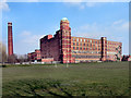
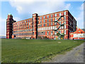
Butts Mill
Butts Mill is a Grade II listed building, built in 1905 by Stott and Sons of Oldham.
This cotton spinning mill, on Butts Street, was originally designed as a double mill and has one wall unfinished. The mirror half of the mill was never built. It is the only large, early twentieth century cotton spinning mill in the Wigan district and one of the best surviving examples of its type in the Greater Manchester area. http://www.britishlistedbuildings.co.uk/en-436632-butts-mill-leigh - British Listed Buildings
Image: © David Dixon
Taken: 24 Mar 2011
0.18 miles
9
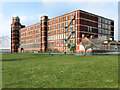
Butts Mill, Leigh
Butts Mill is a Grade II listed building. It was built in 1905 by Stott and Sons of Oldham. This cotton spinning mill was originally designed as a double mill and has one wall unfinished. The mirror half of the mill was never built. It is the only large, early twentieth century cotton spinning mill in the Wigan district and one of the best surviving examples of its type in the Greater Manchester area. http://www.britishlistedbuildings.co.uk/en-436632-butts-mill-leigh - British Listed Buildings
Image: © David Dixon
Taken: 24 Mar 2011
0.18 miles
10
Butts Mill
Butts Mill is a Grade II listed building, built in 1905 by Stott and Sons of Oldham.
This cotton spinning mill, on Butts Street, was originally designed as a double mill and has one wall unfinished. The mirror half of the mill was never built. It is the only large, early twentieth century cotton spinning mill in the Wigan district and one of the best surviving examples of its type in the Greater Manchester area. http://www.britishlistedbuildings.co.uk/en-436632-butts-mill-leigh - British Listed Buildings
Image: © David Dixon
Taken: 24 Mar 2011
0.18 miles