IMAGES TAKEN NEAR TO
Dakins Road, LEIGH, WN7 3AY
Introduction
This page details the photographs taken nearby to Dakins Road, WN7 3AY by members of the Geograph project.
The Geograph project started in 2005 with the aim of publishing, organising and preserving representative images for every square kilometre of Great Britain, Ireland and the Isle of Man.

There are currently over 7.5m images from over14,400 individuals and you can help contribute to the project by visiting https://www.geograph.org.uk
Image Map
Images are licensed for reuse under creativecommons.org/licenses/by-sa/2.0
Notes
- Clicking on the map will re-center to the selected point.
- The higher the marker number, the further away the image location is from the centre of the postcode.
Image Listing (7 Images Found)
Images are licensed for reuse under creativecommons.org/licenses/by-sa/2.0
Image
Details
Distance
4
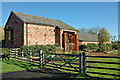
Hope Carr Nature Reserve Visitor's Centre
Until 1990, the site was a grassy desert alongside a wastewater treatment works. It has been transformed by United Utilities into a complex array of wetland habitats, wild flower meadows, and hedgerows. Lakes, ponds and wader ‘scrapes' have been dug, and banks raised to provide cover. 130 different species of birds now find a home in this semi-urban environment.
Image: © Dave Green
Taken: 9 Oct 2005
0.22 miles
5
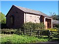
Hope Carr Terrace at Hope Withins Nature Reserve
Wild life instruction and preservation classes are taught here
Image: © Raymond Knapman
Taken: 4 Oct 2010
0.22 miles
6
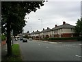
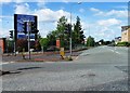
Warrington Road, Leigh.
Looking south down Warrington Road, Leigh near its junction with Hope Carr Road. Typical housing for this part of Leigh. SJ 66919792.
Image: © Keith Williamson
Taken: 11 Sep 2005
0.22 miles