IMAGES TAKEN NEAR TO
Beech Crescent, WIGAN, WN6 0YG
Introduction
This page details the photographs taken nearby to Beech Crescent, WN6 0YG by members of the Geograph project.
The Geograph project started in 2005 with the aim of publishing, organising and preserving representative images for every square kilometre of Great Britain, Ireland and the Isle of Man.

There are currently over 7.5m images from over14,400 individuals and you can help contribute to the project by visiting https://www.geograph.org.uk
Image Map
Images are licensed for reuse under creativecommons.org/licenses/by-sa/2.0
Notes
- Clicking on the map will re-center to the selected point.
- The higher the marker number, the further away the image location is from the centre of the postcode.
Image Listing (7 Images Found)
Images are licensed for reuse under creativecommons.org/licenses/by-sa/2.0
Image
Details
Distance
1

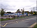
Water Tower from Standish Cricket Club
Rumour has it that this welcome green spot with its distinctive water tower will shortly be being replaced by houses.
Image: © David Hignett
Taken: 31 Aug 2005
0.05 miles
2
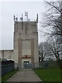
Water, Tower, Green Lane
This water tower is on the South East boundary of Standish Cricket Club.
Image: © Edward Marshall
Taken: 18 Apr 2010
0.11 miles
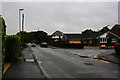
4
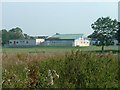
Wood Fold Primary School
Viewed looking north-east from the deeply-potholed Beech Walk, the rear aspect of this school is surprisingly one of the few distinctive features of this grid square... besides a graveyard!
Image: © David Hignett
Taken: 31 Aug 2005
0.21 miles
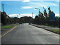
5
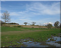
Near Standish Hall
Farmland to the north east of Shevington
Image: © Gary Rogers
Taken: 11 Apr 2009
0.22 miles