IMAGES TAKEN NEAR TO
Bradley Lane, WIGAN, WN6 0XE
Introduction
This page details the photographs taken nearby to Bradley Lane, WN6 0XE by members of the Geograph project.
The Geograph project started in 2005 with the aim of publishing, organising and preserving representative images for every square kilometre of Great Britain, Ireland and the Isle of Man.

There are currently over 7.5m images from over14,400 individuals and you can help contribute to the project by visiting https://www.geograph.org.uk
Image Map
Images are licensed for reuse under creativecommons.org/licenses/by-sa/2.0
Notes
- Clicking on the map will re-center to the selected point.
- The higher the marker number, the further away the image location is from the centre of the postcode.
Image Listing (13 Images Found)
Images are licensed for reuse under creativecommons.org/licenses/by-sa/2.0
Image
Details
Distance
1
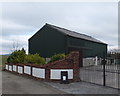
Just for Fun Costume Hire
At Dam House Farm, Standish
Image: © Gary Rogers
Taken: 15 Mar 2016
0.01 miles
4

Path from Avondale Street to Sheldon Avenue, Standish
Image: © Gary Rogers
Taken: 15 Mar 2016
0.10 miles
5

Stream East of Littleton Grove, Standish
Image: © Gary Rogers
Taken: 15 Mar 2016
0.10 miles
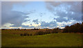
6
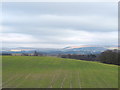
Fields North of Dam House, Standish
Looking East to Winter Hill
Image: © Gary Rogers
Taken: 15 Mar 2016
0.11 miles
7
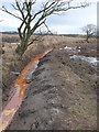
Field drain North of Dam House, Standish
Image: © Gary Rogers
Taken: 15 Mar 2016
0.15 miles
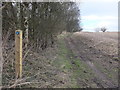
8
Path to Bradley Hall from Gorse Hall, Standish
Image: © Gary Rogers
Taken: 15 Mar 2016
0.15 miles
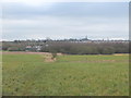
9
A rare gap between rows of metal fencing allows a view of the fields of Worthington
Image: © Ian Greig
Taken: 9 Dec 2011
0.16 miles
10
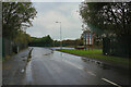
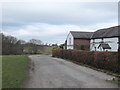
Bradley Lane
We have just passed the industrial estate and are about to enter the village of Standish.
Image: © Malcolm Neal
Taken: 5 Oct 2021
0.18 miles