IMAGES TAKEN NEAR TO
Ashfield House Gardens, WIGAN, WN6 0FA
Introduction
This page details the photographs taken nearby to Ashfield House Gardens, WN6 0FA by members of the Geograph project.
The Geograph project started in 2005 with the aim of publishing, organising and preserving representative images for every square kilometre of Great Britain, Ireland and the Isle of Man.

There are currently over 7.5m images from over14,400 individuals and you can help contribute to the project by visiting https://www.geograph.org.uk
Image Map
Images are licensed for reuse under creativecommons.org/licenses/by-sa/2.0
Notes
- Clicking on the map will re-center to the selected point.
- The higher the marker number, the further away the image location is from the centre of the postcode.
Image Listing (8 Images Found)
Images are licensed for reuse under creativecommons.org/licenses/by-sa/2.0
Image
Details
Distance
1
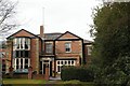
Ashfield House, Standish
This fine building is now a hotel. It has been Council Offices with a baby clinic and even a ball room.
Image: © Edward Marshall
Taken: 21 Mar 2010
0.05 miles
2
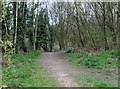
Fairhurst Lane Footpath
This is now the beginning of Fairhurst Lane, originally it started at the bottom of Grove Lane.
Image: © Edward Marshall
Taken: 18 Apr 2010
0.16 miles
3
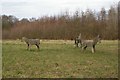
Wooden animals
These are wooden seats provided by the local authority.
Image: © Edward Marshall
Taken: 21 Mar 2010
0.18 miles
5

Bridge over stream, Fairhurst Lane
This stream used to flow down the old Fairhurst lane. In winter it would turn the footpath into an ice rink!
Image: © Edward Marshall
Taken: 18 Apr 2010
0.20 miles
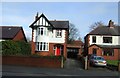
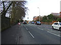
6
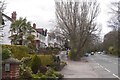
Wigan Road, Standish
Ribbon development along the A49.
Image: © Richard Webb
Taken: 17 Apr 2016
0.21 miles
8
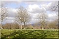
Ashfield Park
A break in the ribbon development along the A49.
Image: © Richard Webb
Taken: 17 Apr 2016
0.24 miles