IMAGES TAKEN NEAR TO
Rivers Street, WIGAN, WN5 8NJ
Introduction
This page details the photographs taken nearby to Rivers Street, WN5 8NJ by members of the Geograph project.
The Geograph project started in 2005 with the aim of publishing, organising and preserving representative images for every square kilometre of Great Britain, Ireland and the Isle of Man.

There are currently over 7.5m images from over14,400 individuals and you can help contribute to the project by visiting https://www.geograph.org.uk
Image Map
Images are licensed for reuse under creativecommons.org/licenses/by-sa/2.0
Notes
- Clicking on the map will re-center to the selected point.
- The higher the marker number, the further away the image location is from the centre of the postcode.
Image Listing (38 Images Found)
Images are licensed for reuse under creativecommons.org/licenses/by-sa/2.0
Image
Details
Distance
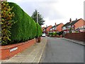
1
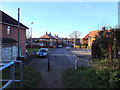
Rivers Street from Edge Hall Road footpath, Orrell
Image: © Gary Rogers
Taken: 28 Nov 2016
0.05 miles
3
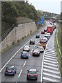
Rush hour on the M58
Approaching the M58/M6 interchange at Orrell. Work is in progress to decrease congestion at this point.
Image: © Gary Rogers
Taken: 13 Oct 2014
0.13 miles
5
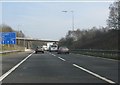
The end is nigh for the M58
The motorway approaches the somewhat odd junction at its meeting with the M6, seemingly designed to create maximum traffic flow conflicts. Counter-intuitively, northbound traffic from the M58 takes the right hand lane. Moor Road crosses on the bridge in the distance. For more about this junction, see: http://www.cbrd.co.uk/badjunctions/6-58/.
Image: © Peter Whatley
Taken: 23 Mar 2012
0.13 miles

8
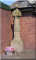
The Post at Orrell Post
Once used as a marker for the junction between ancient rights of way, the stone marker post nestles protected by the brick walls of the Stag Inn
Image: © David Hignett
Taken: 17 Aug 2005
0.16 miles
9
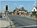
Orrell Post Crossroads
Standing at the Junction of the roads to Winstanley, Shevington, Up Holland and Wigan, the Stag Public House stands on the site of an ancient Inn.
Image: © David Hignett
Taken: 17 Aug 2005
0.16 miles
10
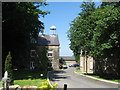
The Nunnery, Orrell
This Benedictine nunnery was established at Mount Orrell in 1821.
Image: © Sue Adair
Taken: 5 Jun 2007
0.16 miles