IMAGES TAKEN NEAR TO
Tithebarn Road, WIGAN, WN4 0YB
Introduction
This page details the photographs taken nearby to Tithebarn Road, WN4 0YB by members of the Geograph project.
The Geograph project started in 2005 with the aim of publishing, organising and preserving representative images for every square kilometre of Great Britain, Ireland and the Isle of Man.

There are currently over 7.5m images from over14,400 individuals and you can help contribute to the project by visiting https://www.geograph.org.uk
Image Map
Images are licensed for reuse under creativecommons.org/licenses/by-sa/2.0
Notes
- Clicking on the map will re-center to the selected point.
- The higher the marker number, the further away the image location is from the centre of the postcode.
Image Listing (10 Images Found)
Images are licensed for reuse under creativecommons.org/licenses/by-sa/2.0
Image
Details
Distance

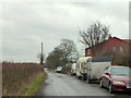
4
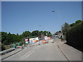
Road Closure in Garswood
The railway line is to be electrified and this bridge had to be raised. The road was closed for approximately 4 months.
Image: © Eileen Littler
Taken: 27 May 2012
0.11 miles
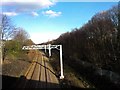
5
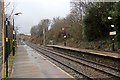
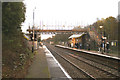
End of platform, Garswood railway station
Looking in the direction of Liverpool, some new catenary masts have been erected, for the electrification of the Liverpool to Wigan line, in 2014. The Garswood Road bridge is in the distance.
Image: © El Pollock
Taken: 30 Dec 2013
0.16 miles