IMAGES TAKEN NEAR TO
Cemetery Road, WIGAN, WN3 4NL
Introduction
This page details the photographs taken nearby to Cemetery Road, WN3 4NL by members of the Geograph project.
The Geograph project started in 2005 with the aim of publishing, organising and preserving representative images for every square kilometre of Great Britain, Ireland and the Isle of Man.

There are currently over 7.5m images from over14,400 individuals and you can help contribute to the project by visiting https://www.geograph.org.uk
Image Map
Images are licensed for reuse under creativecommons.org/licenses/by-sa/2.0
Notes
- Clicking on the map will re-center to the selected point.
- The higher the marker number, the further away the image location is from the centre of the postcode.
Image Listing (180 Images Found)
Images are licensed for reuse under creativecommons.org/licenses/by-sa/2.0
Image
Details
Distance
1
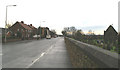
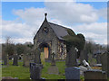
Cemetery Road, Lower Ince
The Cemetery built for Ince Council in the 1850s. The chapel is one of two in the cemetery, both are Grade II listed, but have been neglected and are in a semi-ruined state.
Image: © David Long
Taken: 24 Nov 2006
0.01 miles
2

The Coaching Inn, on the Junction of Warrington Road and Cemetery Road
An ugly building, visible from the M6 to the west. Rarely open as a pub, but fully functioning as a Hotel.
Image: © David Long
Taken: 14 Mar 2005
0.02 miles
3
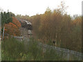
The end of the line at Springs Branch
Once a busy line, serving collieries, iron works, and wagon works, linking them to the main London - Glasgow line - it is reduced to being somewhere to shunt scrap rolling stock.
Image: © David Long
Taken: 23 Nov 2005
0.02 miles
4

Scrap locos on Springs Branch
Everything reusable has been stripped from these locos at the EWS Depot here. Over the next few months the shells were transported out on low-loaders for final disposal.
Image: © David Long
Taken: 17 Jun 2005
0.02 miles
5
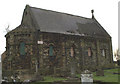
Alfred Waterhouse in Ince-in-Makerfield
The Lodge and Chapels for the township of Ince, in Warrington Road, Lower Ince, were designed by the famous and prolific Liverpool-born Architect Alfred Waterhouse in 1855. Although the Lodge is now in private ownership and has been renovated in recent years, the Chapels are still owned by Wigan Council and have received no care or maintenance for many years. This is the Non-conformist Chapel. It is much more ornate than the adjacent C of E Chapel having a mini-apse at the East end, and an elaborate doorway at the West end. All the buildings are Grade 2 Listed, but this does not guarantee the Chapels' survival, sadly.
Image: © David Long
Taken: 16 Feb 2009
0.03 miles
7
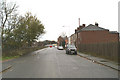
Looking up Cemetery Road, Lower Ince
Taken from the bridge over the WCML {West Coast Main Line}. Ince Urban District's Cemetery lies over the wall on the left.
Image: © David Long
Taken: 24 Nov 2006
0.04 miles
9
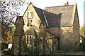
Former Lodge at Ince Cemetery, Warrington Road, Lower Ince
The lodge is now a private dwelling. The Cemetery was formerly that of the now defunct Ince Urban District Council, passing to the Metropolitan Borough of Wigan in 1974.
Image: © David Long
Taken: 14 Nov 2005
0.04 miles
10
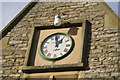
Detail of Cemetery Lodge, showing locally-made clock
Image: © David Long
Taken: 15 Nov 2005
0.04 miles