IMAGES TAKEN NEAR TO
Sherwood Way, WIGAN, WN2 5FD
Introduction
This page details the photographs taken nearby to Sherwood Way, WN2 5FD by members of the Geograph project.
The Geograph project started in 2005 with the aim of publishing, organising and preserving representative images for every square kilometre of Great Britain, Ireland and the Isle of Man.

There are currently over 7.5m images from over14,400 individuals and you can help contribute to the project by visiting https://www.geograph.org.uk
Image Map
Images are licensed for reuse under creativecommons.org/licenses/by-sa/2.0
Notes
- Clicking on the map will re-center to the selected point.
- The higher the marker number, the further away the image location is from the centre of the postcode.
Image Listing (23 Images Found)
Images are licensed for reuse under creativecommons.org/licenses/by-sa/2.0
Image
Details
Distance
1
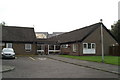
Sherwood House
This care home is reaching the end of its life. The building seen in the background is the first phase of a retirement village. Most of the Sherwood House residents will be transferred there upon its completion, and the site will be cleared for the next phase of the development.
Image: © David Long
Taken: 15 Sep 2008
0.03 miles
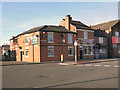
3
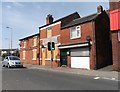
The Queens Arms, Platt Bridge
The Queens Arms public house at the junction of Walthew Lane (A573) and Liverpool Road (A58) in Platt Bridge.
Image: © David Dixon
Taken: 23 Feb 2012
0.05 miles
4
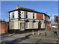
'King William', Platt Bridge
Closed and boarded up in June 2018.
Image: © Roger Cornfoot
Taken: 23 Jun 2018
0.07 miles
5
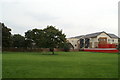
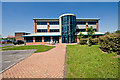
Change in view
The first phase of the'Belong' retirement village beside Sherwood House, which it replaces.
Image: © David Long
Taken: 15 Sep 2008
0.07 miles
6
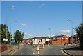
A busy junction at the end of New Street, Abram
Image: © Ian Greig
Taken: 8 Oct 2010
0.08 miles
7
The King William
The King William public house on Liverpool Road (A58) at Platt Bridge.
Image: © David Dixon
Taken: 23 Feb 2012
0.08 miles
8
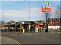
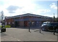
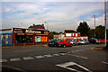
McDonald's, Platt Bridge
The McDonald's, fast food restaurant and drive-through takeaway, on Liverpool Road (A58) at Platt Bridge.
Image: © David Dixon
Taken: 23 Feb 2012
0.10 miles