IMAGES TAKEN NEAR TO
Cavendish Avenue, PONTEFRACT, WF8 2UU
Introduction
This page details the photographs taken nearby to Cavendish Avenue, WF8 2UU by members of the Geograph project.
The Geograph project started in 2005 with the aim of publishing, organising and preserving representative images for every square kilometre of Great Britain, Ireland and the Isle of Man.

There are currently over 7.5m images from over14,400 individuals and you can help contribute to the project by visiting https://www.geograph.org.uk
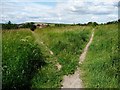
Image Map
Images are licensed for reuse under creativecommons.org/licenses/by-sa/2.0
Notes
- Clicking on the map will re-center to the selected point.
- The higher the marker number, the further away the image location is from the centre of the postcode.
Image Listing (26 Images Found)
Images are licensed for reuse under creativecommons.org/licenses/by-sa/2.0
Image
Details
Distance
1
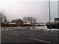
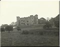
Site of Pontefract New Hall
Where the Elizabethan New Hall stood. Demolished abt 1960
Image: © derek dye
Taken: 16 Jan 2013
0.15 miles
2
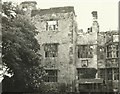
New Hall, Pontefract
This photo shows Pontefract's ruined Elizabethan mansion, New Hall, which was demolished in 1965. My father took this photograph, probably in 1964 or 1965.
Image: © Phillip Beadham
Taken: 1 Aug 1965
0.18 miles
4
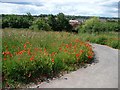
Tarmac path with poppies, Orchard Head
The path zigzags down the hill from Orchard Head Lane to Monkhill Lane.
Image: © Christine Johnstone
Taken: 24 Jun 2011
0.18 miles
5
New Hall, Pontefract
New Hall was an Elizabethan mansion built in 1591 by Edward Talbot, from a design by Robert Smythson, the architect of the famous Hardwick Hall in Derbyshire. New Hall was a defensive site in the English Civil War, and suffered from cannon fire. Later, lead was stripped from New Hall's roof; its timbers started to decay; and eventually the building became a ruin. Finally, this historic building was demolished with explosives in 1965. This photograph was taken by my father, in probably either 1964 or 1965.
Image: © Phillip Beadham
Taken: 1 Aug 1965
0.19 miles
6
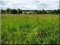
Tall grass off Orchard Head Lane
An 'open space' or a field? Grassland bisected by paths at the edge of a former council estate.
Image: © Christine Johnstone
Taken: 24 Jun 2011
0.19 miles
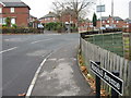
7
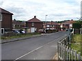
Nevison Avenue
Seen from the northern junction with Mill Lane.
Image: © Christine Johnstone
Taken: 24 Jun 2011
0.19 miles
8
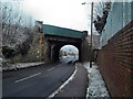
Railway Bridge crossing Ferrybridge Road Pontefract
Image: © derek dye
Taken: 16 Jan 2013
0.19 miles
9
The path divides at Orchard Head
Straight on to return eventually to Orchard Head Lane, left to a path dropping down to Monkhill Lane.
Image: © Christine Johnstone
Taken: 24 Jun 2011
0.20 miles
10
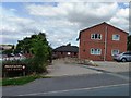
Millfields Care Home, off Mill Lane
Millfields is a care home providing personal care and accommodation for 38 older people who may also have dementia, mental health needs or physical disabilities.
Image: © Christine Johnstone
Taken: 24 Jun 2011
0.20 miles