IMAGES TAKEN NEAR TO
The Chestnuts, PONTEFRACT, WF8 2QH
Introduction
This page details the photographs taken nearby to The Chestnuts, WF8 2QH by members of the Geograph project.
The Geograph project started in 2005 with the aim of publishing, organising and preserving representative images for every square kilometre of Great Britain, Ireland and the Isle of Man.

There are currently over 7.5m images from over14,400 individuals and you can help contribute to the project by visiting https://www.geograph.org.uk
Image Map
Images are licensed for reuse under creativecommons.org/licenses/by-sa/2.0
Notes
- Clicking on the map will re-center to the selected point.
- The higher the marker number, the further away the image location is from the centre of the postcode.
Image Listing (17 Images Found)
Images are licensed for reuse under creativecommons.org/licenses/by-sa/2.0
Image
Details
Distance
2
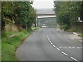
Pontefract Road, Ferrybridge, the new A1 flyovers.
These flyovers cross Pontefract between Ferrybridge and Nevison's Leap, Pontefract.
Image: © Bill Henderson
Taken: 16 Sep 2006
0.10 miles
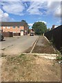
3
Access to Field to rear of Pontefract Road
Image: © Darren Haddock
Taken: 24 Aug 2018
0.11 miles
4
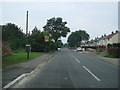
Ferrybridge Road, Nevison, Pontefract, looking south west towards Pontefract Town centre.
The tree on the left side of the road, is at the end of Stump Cross Lane. At the base of the tree is the base of an ancient cross which once marked the boundary of Pontefract. This boundary stone is in grid square SE 469234.
Image: © Bill Henderson
Taken: 16 Sep 2006
0.14 miles
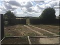
5

"Stumpcross" base
Base of stumpcross boundary marker
Image: © derek dye
Taken: 1 May 2011
0.14 miles
6
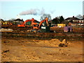
New housing under construction at Pontefract
Image: © derek dye
Taken: 16 Dec 2019
0.15 miles

8
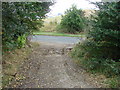
Footpath from Sowgate Lane, exiting on to Ferrybridge Road
Image: © Bill Henderson
Taken: 12 Oct 2007
0.18 miles
9

Stump Cross base
All that remains of a wayside cross possibly 12th century marking diocese boundaries.
Image: © derek dye
Taken: 15 Jan 2018
0.19 miles
