IMAGES TAKEN NEAR TO
Lake Lock Grove, WAKEFIELD, WF3 4JJ
Introduction
This page details the photographs taken nearby to Lake Lock Grove, WF3 4JJ by members of the Geograph project.
The Geograph project started in 2005 with the aim of publishing, organising and preserving representative images for every square kilometre of Great Britain, Ireland and the Isle of Man.

There are currently over 7.5m images from over14,400 individuals and you can help contribute to the project by visiting https://www.geograph.org.uk
Image Map
Images are licensed for reuse under creativecommons.org/licenses/by-sa/2.0
Notes
- Clicking on the map will re-center to the selected point.
- The higher the marker number, the further away the image location is from the centre of the postcode.
Image Listing (175 Images Found)
Images are licensed for reuse under creativecommons.org/licenses/by-sa/2.0
Image
Details
Distance
1
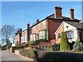
Houses on the west side of Aberford Road
Two pairs of Edwardian or late Victorian semis, contrasting with a 1960s bungalow.
Image: © Christine Johnstone
Taken: 10 Mar 2014
0.03 miles
2
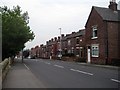
Lake Lock Road
The terraced houses in this road are all dated pre 1900.
Image: © Mike Kirby
Taken: 17 Sep 2008
0.03 miles
3
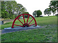
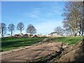
Stanley miners memorial
The half pit wheel is in memory of all the men who worked, and in some cases died, in the local coal mines (a device used elsewhere to similar effect). It was erected in 2017 in the south-east corner of St Peter's churchyard. The church building itself Image closed in 2001 and was demolished in 2014 due, ironically, to mining subsidence.
Image: © Stephen Craven
Taken: 23 Jul 2019
0.05 miles
5
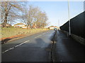
Entrance to St Peter's churchyard
Now used by demolition plant, not parishioners.
Image: © Christine Johnstone
Taken: 10 Mar 2014
0.05 miles
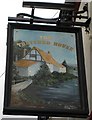
7
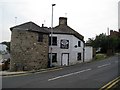
The Thatched House, Aberford Road
Basking in bright early morning sunshine.
Image: © Christine Johnstone
Taken: 10 Mar 2014
0.05 miles
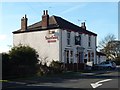
9
Aberford Road
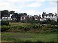
Taken from the River Calder embankment, the building on the right is the rear of the Thatched House public house. Image
Image: © Mike Kirby
Taken: 15 Sep 2009
0.05 miles
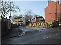
10
Old Toll House
The turnpike road, (now Aberford Road), ran through Stanley and was in use in 1770. The toll house was in use until 1870, when tolls were gradually abolished.
The house is currently undergoing some renovation.
Image: © Mike Kirby
Taken: 17 Sep 2008
0.06 miles