IMAGES TAKEN NEAR TO
Otter Close, WAKEFIELD, WF2 6UF
Introduction
This page details the photographs taken nearby to Otter Close, WF2 6UF by members of the Geograph project.
The Geograph project started in 2005 with the aim of publishing, organising and preserving representative images for every square kilometre of Great Britain, Ireland and the Isle of Man.

There are currently over 7.5m images from over14,400 individuals and you can help contribute to the project by visiting https://www.geograph.org.uk
Image Map
Images are licensed for reuse under creativecommons.org/licenses/by-sa/2.0
Notes
- Clicking on the map will re-center to the selected point.
- The higher the marker number, the further away the image location is from the centre of the postcode.
Image Listing (32 Images Found)
Images are licensed for reuse under creativecommons.org/licenses/by-sa/2.0
Image
Details
Distance
1
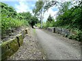
Former lock on the abandoned Barnsley Canal
There were twelve locks on the canal at Walton but the remains of only two can be seen today.
Image: © Graham Hogg
Taken: 2 Aug 2021
0.10 miles
2
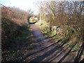
Remains of a lock on the disused Barnsley Canal
The path (part of the Trans Pennine Trail) goes straight through the lock, exactly on the line of the old canal
Image: © John Slater
Taken: 19 Feb 2012
0.10 miles
3
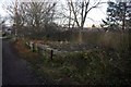
Former lock on the Barnsley Canal
All that remains of a flight of 5 locks here.
Image: © Graham Hogg
Taken: 30 Nov 2012
0.10 miles
4
Remains of a lock on the disused Barnsley Canal
Image: © John Slater
Taken: 19 Feb 2012
0.10 miles
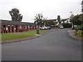
6
Cherry Tree Crescent - Cherry Tree Road
Image: © Betty Longbottom
Taken: 8 Sep 2015
0.14 miles
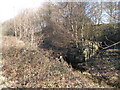
7
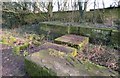
Remains of old canal lock
At this point close to Waterton Park golf club house the long abandoned Barnsley Canal runs out of water. The stonework here is part of a series of 5 locks which took the canal downhill and through Walton village. The canal northwards from here being filled in and part of a cycle track and footpath.
Image: © Gordon Hatton
Taken: 21 Jan 2020
0.15 miles
9
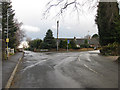
Two dead ends
The road to the right, The Balk, becomes Sike Lane and ends at Haw Park Bridge over the disused Barnsley Canal. The left turn leads to Walton Hall, Waterton Park Hotel and Waterton Park Golf Club.
The blue signs mark the route of the Trans Pennine Trail, a route for walkers, cyclists and horse riders which links the North and Irish Seas. It passes through the Pennines, alongside rivers and canals and through some of the most historic towns and cities in the North of England.
Image: © Pauline E
Taken: 22 Mar 2010
0.16 miles
10
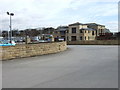
Waterton Park Golf Club
The clubhouse of Waterton Park Golf Club at Walton.
Image: © Ian Russell
Taken: 16 Mar 2007
0.16 miles