IMAGES TAKEN NEAR TO
Hyrstlands Road, BATLEY, WF17 7JT
Introduction
This page details the photographs taken nearby to Hyrstlands Road, WF17 7JT by members of the Geograph project.
The Geograph project started in 2005 with the aim of publishing, organising and preserving representative images for every square kilometre of Great Britain, Ireland and the Isle of Man.

There are currently over 7.5m images from over14,400 individuals and you can help contribute to the project by visiting https://www.geograph.org.uk
Image Map
Images are licensed for reuse under creativecommons.org/licenses/by-sa/2.0
Notes
- Clicking on the map will re-center to the selected point.
- The higher the marker number, the further away the image location is from the centre of the postcode.
Image Listing (121 Images Found)
Images are licensed for reuse under creativecommons.org/licenses/by-sa/2.0
Image
Details
Distance
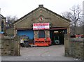
1
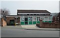
Batley Carr Community Association - Hyrstlands Road
Image: © Betty Longbottom
Taken: 9 Apr 2013
0.02 miles
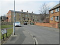
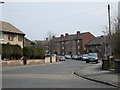
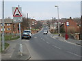
3
Hyrstlands Road - Town Street, Batley Carr
Image: © Betty Longbottom
Taken: 15 Feb 2008
0.03 miles
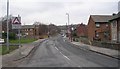
4
Wilson Wood Street - Hyrstlands Road
Image: © Betty Longbottom
Taken: 9 Apr 2013
0.03 miles
7
The Old School - Upper Road, Batley Carr
Erected 1831 - Enlarged 1879.
Image: © Betty Longbottom
Taken: 15 Feb 2008
0.06 miles
8
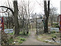
Canary Island Urban Art Garden - Wilson Wood Street
Created in 2000, this displays urban art within the setting of a garden.
Image: © Betty Longbottom
Taken: 9 Apr 2013
0.06 miles
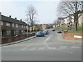
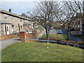
10
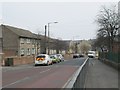
Town Street - viewed from Hyrstlands Road
Image: © Betty Longbottom
Taken: 9 Apr 2013
0.07 miles