IMAGES TAKEN NEAR TO
Duxbury Gardens, LIVERSEDGE, WF15 7FA
Introduction
This page details the photographs taken nearby to Duxbury Gardens, WF15 7FA by members of the Geograph project.
The Geograph project started in 2005 with the aim of publishing, organising and preserving representative images for every square kilometre of Great Britain, Ireland and the Isle of Man.

There are currently over 7.5m images from over14,400 individuals and you can help contribute to the project by visiting https://www.geograph.org.uk
Image Map
Images are licensed for reuse under creativecommons.org/licenses/by-sa/2.0
Notes
- Clicking on the map will re-center to the selected point.
- The higher the marker number, the further away the image location is from the centre of the postcode.
Image Listing (134 Images Found)
Images are licensed for reuse under creativecommons.org/licenses/by-sa/2.0
Image
Details
Distance
1
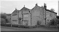
3 Roberttown Lane (Duxbury Hall), Liversedge
Image: © habiloid
Taken: 28 Feb 2024
0.04 miles
2
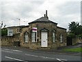
The Toll Bar House - Huddersfield Road
Image: © Betty Longbottom
Taken: 2 Aug 2008
0.04 miles
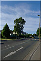
4
Houses on Huddersfield Road (A62), Liversedge
Image: © JThomas
Taken: 6 Mar 2020
0.04 miles
5
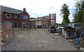
Houses being built in Duxbury Gardens, Liversedge
Image: © habiloid
Taken: 18 Jun 2018
0.05 miles
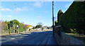
6
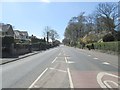
Huddersfield Road - viewed from Liversedge Hall Lane
Image: © Betty Longbottom
Taken: 1 May 2013
0.06 miles
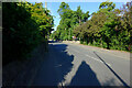
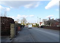
9
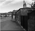
The Toll House, Leeds Road, Liversedge
The Toll House is at the junction of Huddersfield Road (A62) (a small portion of which runs across the centre of the picture) and Roberttown Lane (from where this photo was taken). The house in the background is on Liversedge Hall Lane.
Image: © habiloid
Taken: 18 Jun 2018
0.06 miles
