IMAGES TAKEN NEAR TO
Halifax Road, LIVERSEDGE, WF15 6PP
Introduction
This page details the photographs taken nearby to Halifax Road, WF15 6PP by members of the Geograph project.
The Geograph project started in 2005 with the aim of publishing, organising and preserving representative images for every square kilometre of Great Britain, Ireland and the Isle of Man.

There are currently over 7.5m images from over14,400 individuals and you can help contribute to the project by visiting https://www.geograph.org.uk
Image Map
Images are licensed for reuse under creativecommons.org/licenses/by-sa/2.0
Notes
- Clicking on the map will re-center to the selected point.
- The higher the marker number, the further away the image location is from the centre of the postcode.
Image Listing (142 Images Found)
Images are licensed for reuse under creativecommons.org/licenses/by-sa/2.0
Image
Details
Distance
1
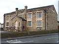
National School - Halifax Road
Built in 1818 - now converted for residential use.
Image: © Betty Longbottom
Taken: 20 Nov 2012
0.00 miles
2
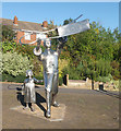
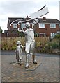
A Hightown cropper and his daughter, Liversedge Sparrow Park
Statue of a Hightown cropper and his daughter by Xceptional Designs (2012), Liversedge Sparrow Park. A memorial to the Luddite struggles of the early nineteenth century.
Image: © habiloid
Taken: 21 Sep 2019
0.01 miles

5
Commemorative Statue - Halifax Road
This was erected in 2012 on the 200th anniversary of the Luddite Uprising of 1812.
Image: © Betty Longbottom
Taken: 20 Nov 2012
0.02 miles
6
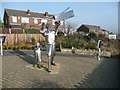
The Luddite Memorial statue, Halifax Road, Liversedge
This depicts a cropper brandishing his shears, which were used to crop off fibres projecting from pieces of cloth, a skilled task. It was the mechanisation of this process that led to the Luddite riots. The little girl has a worried, adult-looking face, perhaps representing how her mother felt about the hopeless bravado of her father.
Image: © Humphrey Bolton
Taken: 18 Feb 2013
0.02 miles
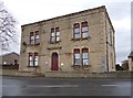
7
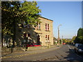
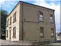
Former Town Hall, Liversedge
From 1894 to 1915, when it joined with its neighbouring authorities to form Spenborough UDC, Liversedge was an Urban District Council and this was the Town Hall. It is at the junction of Knowler Hill with Halifax Road.
Image: © Humphrey Bolton
Taken: 27 Oct 2005
0.02 miles
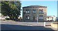
8
Old Town Hall - Halifax Road
Now converted into flats.
Image: © Betty Longbottom
Taken: 20 Nov 2012
0.02 miles