IMAGES TAKEN NEAR TO
The Knowl, MIRFIELD, WF14 9RH
Introduction
This page details the photographs taken nearby to The Knowl, WF14 9RH by members of the Geograph project.
The Geograph project started in 2005 with the aim of publishing, organising and preserving representative images for every square kilometre of Great Britain, Ireland and the Isle of Man.

There are currently over 7.5m images from over14,400 individuals and you can help contribute to the project by visiting https://www.geograph.org.uk
Image Map
Images are licensed for reuse under creativecommons.org/licenses/by-sa/2.0
Notes
- Clicking on the map will re-center to the selected point.
- The higher the marker number, the further away the image location is from the centre of the postcode.
Image Listing (95 Images Found)
Images are licensed for reuse under creativecommons.org/licenses/by-sa/2.0
Image
Details
Distance
4
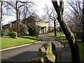
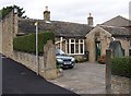
Westfield House, Knowl Road, Mirfield
A Christadelphian rest home.
Image: © Humphrey Bolton
Taken: 11 Feb 2007
0.05 miles
5
Ivy Cottage, Knowl Road, Mirfield
This has a stone tablet over the door from when the building was an endowed free grammar school.
Image: © Humphrey Bolton
Taken: 19 Sep 2005
0.05 miles
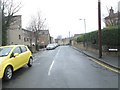
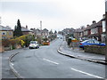
6
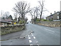
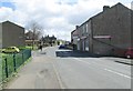
Knowl Road - viewed from Crowther Road
Image: © Betty Longbottom
Taken: 25 Mar 2014
0.06 miles
7
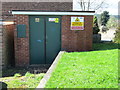
Electricity Substation No 649 - The Knowl
Image: © Betty Longbottom
Taken: 8 Apr 2014
0.07 miles
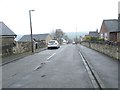
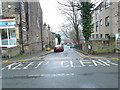
10
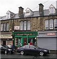
Former Post Office - The Knowl - Knowl Road
Image: © Betty Longbottom
Taken: 2 Aug 2008
0.08 miles