IMAGES TAKEN NEAR TO
Nab Lane, MIRFIELD, WF14 9QJ
Introduction
This page details the photographs taken nearby to Nab Lane, WF14 9QJ by members of the Geograph project.
The Geograph project started in 2005 with the aim of publishing, organising and preserving representative images for every square kilometre of Great Britain, Ireland and the Isle of Man.

There are currently over 7.5m images from over14,400 individuals and you can help contribute to the project by visiting https://www.geograph.org.uk
Image Map
Images are licensed for reuse under creativecommons.org/licenses/by-sa/2.0
Notes
- Clicking on the map will re-center to the selected point.
- The higher the marker number, the further away the image location is from the centre of the postcode.
Image Listing (89 Images Found)
Images are licensed for reuse under creativecommons.org/licenses/by-sa/2.0
Image
Details
Distance
3
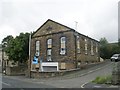
Former Primitive Methodist Chapel - Nab Lane
Built 1865.
Image: © Betty Longbottom
Taken: 10 Aug 2009
0.02 miles
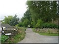
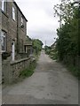
7
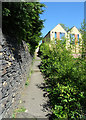
Path between The Clough and Stocks Bank Road, Mirfield
Image: © habiloid
Taken: 24 Apr 2020
0.07 miles
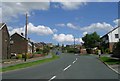
8
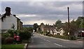
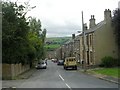
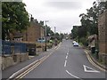
Nab Lane, Mirfield
This is looking westwards down to Stocksbank Road. There is a Primitive Methodist Chapel on the right-hand side of the road in the distance.
Image: © Humphrey Bolton
Taken: 19 Sep 2005
0.07 miles