IMAGES TAKEN NEAR TO
Ingham Garth, MIRFIELD, WF14 9NR
Introduction
This page details the photographs taken nearby to Ingham Garth, WF14 9NR by members of the Geograph project.
The Geograph project started in 2005 with the aim of publishing, organising and preserving representative images for every square kilometre of Great Britain, Ireland and the Isle of Man.

There are currently over 7.5m images from over14,400 individuals and you can help contribute to the project by visiting https://www.geograph.org.uk
Image Map
Images are licensed for reuse under creativecommons.org/licenses/by-sa/2.0
Notes
- Clicking on the map will re-center to the selected point.
- The higher the marker number, the further away the image location is from the centre of the postcode.
Image Listing (104 Images Found)
Images are licensed for reuse under creativecommons.org/licenses/by-sa/2.0
Image
Details
Distance
4
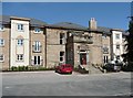
The Marma Villa in its new guise
The central frontage of the Edwardian mansion is now the centre-piece of a large block of apartments. See Image
Image: © Humphrey Bolton
Taken: 7 Jun 2013
0.10 miles
5
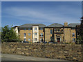
Marmaville Court, Church Lane
The completed new housing development includes the front entrance (but nothing else) of the original Marma Villa Image
Part of the engineering project referred to in the shared description included new drainage for the buildings of the original Marmaville estate. Whether it remains in use and adequate for the larger number of dwellings on the site, I don't know.
Image: © Stephen Craven
Taken: 17 Jun 2017
0.10 miles
6
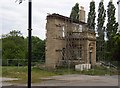
What is left of the Marma Villa, Church Lane, Mirfield
This was an Edwardian mansion, with two lodges that still exist and have been modernised. It eventually became a country club, renamed as The Marmaville, and then a pub / restaurant. Over the years it had some ugly extensions and looked to be quite a mess. Then it was bought for redevelopment and during a long planning wrangle everything was demolished apart from the front façade, which is now waiting patiently for a block of flats to be stitched onto it.
Image: © Humphrey Bolton
Taken: 30 May 2006
0.10 miles
7
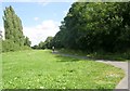
Calder Valley Greenway - Church Lane
Image: © Betty Longbottom
Taken: 29 Jul 2008
0.10 miles
8

Lodge Drive, Mirfield
This was built c.1973 by Ashton Homes, around the same time as the adjacent Blake Hall Estate. It is open-plan at the front, giving a village green effect. Most of the houses have been extended from the original plan of one room each side of the front door. The price of the houses with the larger plots was £8500!
Image: © Humphrey Bolton
Taken: 4 Mar 2010
0.11 miles
9
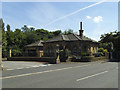
Marmaville Lodge, Church Lane
The former Marma Villa Image has been largely demolished (part from its facade) but the lodges remain. This is the lower one.
Image: © Stephen Craven
Taken: 17 Jun 2017
0.12 miles