
IMAGES TAKEN NEAR TO
Calder Road, MIRFIELD, WF14 8NR
Introduction
This page details the photographs taken nearby to Calder Road, WF14 8NR by members of the Geograph project.
The Geograph project started in 2005 with the aim of publishing, organising and preserving representative images for every square kilometre of Great Britain, Ireland and the Isle of Man.

There are currently over 7.5m images from over14,400 individuals and you can help contribute to the project by visiting https://www.geograph.org.uk
Image Map
Images are licensed for reuse under creativecommons.org/licenses/by-sa/2.0
Notes
- Clicking on the map will re-center to the selected point.
- The higher the marker number, the further away the image location is from the centre of the postcode.
Image Listing (318 Images Found)
Images are licensed for reuse under creativecommons.org/licenses/by-sa/2.0
Image
Details
Distance

2

Former Co-operative store, Waste Lane, Mirfield
The inscription above the original entrance, readable on the original high-resolution image (available on request) is "Mirfield Industrial Co-operative Society Limited Branch No. 25" (at least I make the number 25, which also appears at the top of the inscription, rather than 1 as suggested by another contributor Image
Image: © Stephen Craven
Taken: 21 Dec 2021
0.02 miles
3

Mirfield Industrial Co-operative Society Ltd - No 1 Branch - Waste Lane
Image: © Betty Longbottom
Taken: 4 Oct 2010
0.02 miles
4

Electricity Substation No 782 - Marshall Street
Image: © Betty Longbottom
Taken: 29 Jul 2014
0.03 miles
5

Ledgard Bridge Mill off Back Station Road, Mirfield (SE201194)
This is part of an industrial area between Back Station Road, which runs alongside the railway, and the River Calder.
Image: © Humphrey Bolton
Taken: 28 Feb 2006
0.03 miles
6
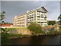
The Ledgard Mills apartment block, Mirfield
The original building is barely recognisable, but it is good that it has been used. The extension towards the river does not attempt to match the older part. The white strip on the river wall is a depth gauge.
Image: © Humphrey Bolton
Taken: 18 Sep 2008
0.03 miles


