
IMAGES TAKEN NEAR TO
Station Road, MIRFIELD, WF14 8NA
Introduction
This page details the photographs taken nearby to Station Road, WF14 8NA by members of the Geograph project.
The Geograph project started in 2005 with the aim of publishing, organising and preserving representative images for every square kilometre of Great Britain, Ireland and the Isle of Man.

There are currently over 7.5m images from over14,400 individuals and you can help contribute to the project by visiting https://www.geograph.org.uk
Image Map
Images are licensed for reuse under creativecommons.org/licenses/by-sa/2.0
Notes
- Clicking on the map will re-center to the selected point.
- The higher the marker number, the further away the image location is from the centre of the postcode.
Image Listing (101 Images Found)
Images are licensed for reuse under creativecommons.org/licenses/by-sa/2.0
Image
Details
Distance
1

Chimney of Holme Bank Mills
The mill buildings are now part of a business park but the chimney survives.
Image: © Stephen Craven
Taken: 14 Jan 2017
0.02 miles
2

Textile Mill
There are several mills dotted along the length of the River Calder, this being one such example.
Image: © John P Coates
Taken: 12 Sep 2002
0.05 miles
3

Holme Bank Mills, Mirfield
Formerly Walker's fulling mill by the River Calder, now a Business Park. Viewed from Hopton New Road across a field of corn stubble.
Image: © Stephen Craven
Taken: 14 Jan 2017
0.05 miles
4

Caravans and Holme Bank Mills
Caravans on the banks of the River Calder in Mirfield.
Image: © DS Pugh
Taken: 22 Feb 2025
0.05 miles
5
Lowfields Mills, off Hopton New Road, Mirfield (SE206193)
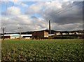
This factory is surrounded by fields. It is on the former route of Hirst Lane, which passes under the railway embankment in a low tunnel. The factory has its own access along a concrete driveway, a public footpath, from Hopton New Road. The old parts of the mill are the stone building in the centre of the photo, with its red paintwork, and the tall mill chimney.
Image: © Humphrey Bolton
Taken: 28 Feb 2006
0.07 miles
6

Housing estate along Steanard Lane
A relatively new housing estate in Mirfield.
Image: © DS Pugh
Taken: 22 Feb 2025
0.07 miles
7

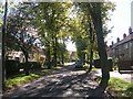
Terraces on Granny Lane, Lower Hopton
A short row of red brick terraces.
Image: © Bobby Clegg
Taken: 20 Jul 2014
0.07 miles
9
Old iron plate on Granny Lane
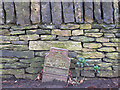
The plate, firmly embedded in the bitumen of the footpath surfacing, bears the Royal crest (GR) and the letters "ft in". There is a space below which was probably intended to have figures giving the distance in feet and inches to something (maybe a telephone cable junction box or similar?)
Image: © Stephen Craven
Taken: 14 Jan 2017
0.09 miles
10

Gate to former coal mine, Granny lane, Lower Hopton, Mirfield
The lettering on the gate is an example of something I have passed many times over a 35 year period, and not noticed until now.
Image: © Humphrey Bolton
Taken: 1 May 2008
0.11 miles