
IMAGES TAKEN NEAR TO
Jill Lane, MIRFIELD, WF14 0DS
Introduction
This page details the photographs taken nearby to Jill Lane, WF14 0DS by members of the Geograph project.
The Geograph project started in 2005 with the aim of publishing, organising and preserving representative images for every square kilometre of Great Britain, Ireland and the Isle of Man.

There are currently over 7.5m images from over14,400 individuals and you can help contribute to the project by visiting https://www.geograph.org.uk
Image Map
Images are licensed for reuse under creativecommons.org/licenses/by-sa/2.0
Notes
- Clicking on the map will re-center to the selected point.
- The higher the marker number, the further away the image location is from the centre of the postcode.
Image Listing (8 Images Found)
Images are licensed for reuse under creativecommons.org/licenses/by-sa/2.0
Image
Details
Distance
1

Jill Lane, Mirfield
This is a pleasant link from Mirfield to the Spen Valley Greenway (Sustrans Route 66). Unfortunately it can't be shown on Kirklees Council's excellent map of cycling routes because it isn't on their street register, neither is it on the Rights of Way map ..... so why does it have a road sign? (Barriers were erected 200m further on, at a particularly squelchy place, to stop motorists from using the lane).
Image: © Humphrey Bolton
Taken: 14 Nov 2005
0.09 miles
2

Railway Bridge near Jill Lane, Northorpe
This bridge carried the now disused Mirfield Branch of the Lancashire and Yorkshire Railway over a footpath leading from Jill Lane. Most of the major bridges over roads have now been demolished, but this structure remains. The reason for the two spans is not clear.
Image: © Richard Kay
Taken: 15 Jan 2009
0.13 miles

4

Trig Point at SE216216
The triangulation pillar is set just inside the fence line next to the disused L.N.W.R. Leeds New Line. The view looks across the lower Spen Valley towards the Church of St. John the Evangelist at Dewsbury Moor.
Image: © Richard Kay
Taken: 15 Jan 2009
0.15 miles
5

Path on dismantled railway at Ponderosa
The railway was the Heaton Lodge & Wortley Line and Ponderosa is a farm zoo attraction for Heckmondwike.
Image: © Kevin Waterhouse
Taken: 20 Aug 2025
0.18 miles
6
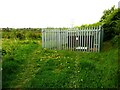
Methane tank in Dewsbury Country Park
I haven't been able to find any information about this, but landfill sites produce methane and there is a methane burner in the park, so presumably the gas from a vent pipe is stored in this tank and then piped to the burner. Burning methane produces carbon dioxide and, unless burnt in oxygen, it also produces Nitrogen oxides.
Image: © Humphrey Bolton
Taken: 28 Apr 2022
0.19 miles
7

The monkey house at Ponderosa, Norristhorpe, Liversedge
With a reptile house to the right, and the children's playground to the left.
Image: © Humphrey Bolton
Taken: 26 Oct 2006
0.20 miles
8

Former Leeds New Line in Northorpe
The remaining bridge abutment at Jill Lane in Northorpe at the point where the ex L&NWR Leeds New Line crossed.
Image: © Bobby Clegg
Taken: 20 Jul 2014
0.25 miles