IMAGES TAKEN NEAR TO
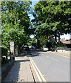
West Park Street, DEWSBURY, WF13 4LA
Introduction
This page details the photographs taken nearby to West Park Street, WF13 4LA by members of the Geograph project.
The Geograph project started in 2005 with the aim of publishing, organising and preserving representative images for every square kilometre of Great Britain, Ireland and the Isle of Man.

There are currently over 7.5m images from over14,400 individuals and you can help contribute to the project by visiting https://www.geograph.org.uk
Image Map
Images are licensed for reuse under creativecommons.org/licenses/by-sa/2.0
Notes
- Clicking on the map will re-center to the selected point.
- The higher the marker number, the further away the image location is from the centre of the postcode.
Image Listing (134 Images Found)
Images are licensed for reuse under creativecommons.org/licenses/by-sa/2.0
Image
Details
Distance
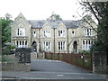
1
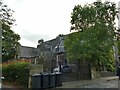
Former St Mark's church hall, Dewsbury
The hall was sold off around the same time as the church itself (c.2000). The present use is unclear.
Image: © Stephen Craven
Taken: 4 Sep 2022
0.02 miles
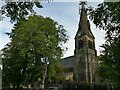
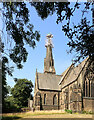
2
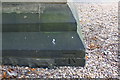
Benchmark on buttress of Dewsbury Gospel Church
Ordnance Survey cut mark benchmark described on the Bench Mark Database at www.bench-marks.org.uk/bm54405
Image: © Roger Templeman
Taken: 30 Aug 2018
0.04 miles
3
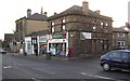
Post Office, Halifax Road, Dewsbury
With a rounded corner, and a house at the back. Then three one-storey lock-up shops and a three storey building with a parapet that would have looked better if carried on along the side. Perhaps the architect was expecting another tall building next door!
Image: © Humphrey Bolton
Taken: 13 Dec 2007
0.04 miles
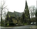
4
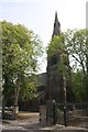
Dewsbury Gospel Church, West Park Street
There is an OS benchmark Image at the base of the near tower buttress. The spire is an OS intersected station trig point, http://trigpointing.uk/trig/14190
Image: © Roger Templeman
Taken: 30 Aug 2018
0.04 miles
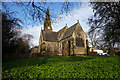
5
Former St Mark's church, Dewsbury - spire
The church on West Park Street was built in 1862-65, architect James Mallinson. It seated c.700 people. It ceased being used for worship c.1996 and was sold in 2000 to the Dewsbury Revival Centre who in 2010 opened the Branch Christian School in the building. Listed Grade II (list entry 1134715).
Image: © Stephen Craven
Taken: 4 Sep 2022
0.04 miles
6
Un-named Church - West Park Street - Halifax Road
Image: © Betty Longbottom
Taken: 27 Feb 2008
0.05 miles
7
Dewsbury's Gospel Church, Halifax Road, Dewsbury
Image: © Ian S
Taken: 18 Apr 2018
0.05 miles
10
Dewsbury Gospel Church seen from Halifax Road (A638), Dewsbury
Image: © habiloid
Taken: 18 Jul 2022
0.06 miles