IMAGES TAKEN NEAR TO
Kiln Lane, DEWSBURY, WF13 1NR
Introduction
This page details the photographs taken nearby to Kiln Lane, WF13 1NR by members of the Geograph project.
The Geograph project started in 2005 with the aim of publishing, organising and preserving representative images for every square kilometre of Great Britain, Ireland and the Isle of Man.

There are currently over 7.5m images from over14,400 individuals and you can help contribute to the project by visiting https://www.geograph.org.uk
Image Map
Images are licensed for reuse under creativecommons.org/licenses/by-sa/2.0
Notes
- Clicking on the map will re-center to the selected point.
- The higher the marker number, the further away the image location is from the centre of the postcode.
Image Listing (384 Images Found)
Images are licensed for reuse under creativecommons.org/licenses/by-sa/2.0
Image
Details
Distance
1
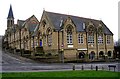
Eastborough Junior & Infants School - Battye Street
Image: © Betty Longbottom
Taken: 15 Feb 2008
0.03 miles
3
Dewsbury Baptist Church - Manor Street
Image: © Betty Longbottom
Taken: 15 Feb 2008
0.04 miles
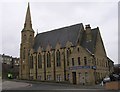
5
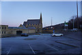
Dewsbury Baptist Church, Wakefield Road, Dewsbury
Image: © Ian S
Taken: 23 Jan 2019
0.05 miles
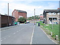
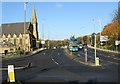
6
Eastborough Crescent - Battye Street
Image: © Betty Longbottom
Taken: 27 Aug 2013
0.06 miles
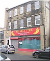
7
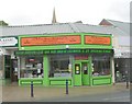
Mochachinno's Takeaway - Crackenedge Lane
Image: © Betty Longbottom
Taken: 10 May 2010
0.06 miles
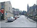
9
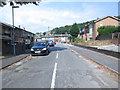
Wakefield Road - viewed from Rishworth Road
Image: © Betty Longbottom
Taken: 12 Nov 2013
0.07 miles
10
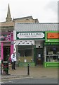
You Well Come Restaurant - Crackenedge Lane
Image: © Betty Longbottom
Taken: 10 May 2010
0.07 miles