
IMAGES TAKEN NEAR TO
Nelson Street, DEWSBURY, WF13 1NA
Introduction
This page details the photographs taken nearby to Nelson Street, WF13 1NA by members of the Geograph project.
The Geograph project started in 2005 with the aim of publishing, organising and preserving representative images for every square kilometre of Great Britain, Ireland and the Isle of Man.

There are currently over 7.5m images from over14,400 individuals and you can help contribute to the project by visiting https://www.geograph.org.uk
Image Map
Images are licensed for reuse under creativecommons.org/licenses/by-sa/2.0
Notes
- Clicking on the map will re-center to the selected point.
- The higher the marker number, the further away the image location is from the centre of the postcode.
Image Listing (785 Images Found)
Images are licensed for reuse under creativecommons.org/licenses/by-sa/2.0
Image
Details
Distance
1
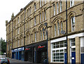
Dewsbury - north side of Nelson Street
Note that Betty Longbottom has provided images of individual shops on this street.
Image: © Dave Bevis
Taken: 31 Jul 2012
0.01 miles
2
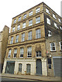
Building on Wellington Street, Dewsbury
Above the door is a monogram "JW 1872" (or is it "WJ 1872"?)
Image: © Stephen Craven
Taken: 18 Jun 2019
0.01 miles
3
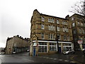
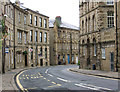
Daisy Hill at the junction of Wellington Street
This part of Dewsbury was once full of woollen warehouses. Most have now found other uses. Some have been demolished but what remain give a distinctive quality to this part of the town.
Image: © Jonathan Thacker
Taken: 19 Feb 2018
0.01 miles
4
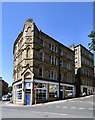
Offices at Daisy Hill
The doorway of the 1873 dated building is on Old Westgate but the sides are on Nelson Street (left) and Wellington Street (right). The doorway bears the initials JM.
Image: © Gerald England
Taken: 28 Jun 2018
0.01 miles
6
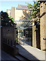
Dewsbury Magistrates' Court
Entrance to The Courthouse in Grove Street.
Image: © David Ward
Taken: 2 Aug 2007
0.02 miles
7

I've lost my roof!
This building formerly associated with the woollen industry appears to have lost its roof and possibly upper storey.
Image: © Jonathan Thacker
Taken: 19 Feb 2018
0.03 miles
8
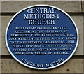
Blue plaque, Central Methodist Church
On Daisy Hill, Dewsbury.http://www.geograph.org.uk/photo/3963542
Image: © Ian S
Taken: 30 Apr 2014
0.03 miles
9

Elim church, Dewsbury
Built in 1839 as Centenary Church eventually becoming the Central Methodist Church and now Elim Pentecostal Church https://www.britishlistedbuildings.co.uk/101134733-central-methodist-church-dewsbury-east-ward#.Wo3ZgOfLjVI
Image: © Jonathan Thacker
Taken: 19 Feb 2018
0.03 miles
10
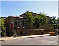
Elim Pentecostal Church
The Wellington Street entrance to Elim church. The Grade II listed building https://historicengland.org.uk/listing/the-list/list-entry/1134733 was built in 1839 as a Wesleyan Chapel. It later became known as Daisy Hill Methodist Church and then Central Methodist Church sharing the building for many years with the Elim Pentecostal Church. The Methodists moved out in 2007 and the building was expected to bought by developers. However it was purchased by the Pentecostal Church who now have exclusive use.
Image: © Gerald England
Taken: 28 Jun 2018
0.03 miles