
IMAGES TAKEN NEAR TO
Mill Street East, DEWSBURY, WF12 9AW
Introduction
This page details the photographs taken nearby to Mill Street East, WF12 9AW by members of the Geograph project.
The Geograph project started in 2005 with the aim of publishing, organising and preserving representative images for every square kilometre of Great Britain, Ireland and the Isle of Man.

There are currently over 7.5m images from over14,400 individuals and you can help contribute to the project by visiting https://www.geograph.org.uk
Image Map
Images are licensed for reuse under creativecommons.org/licenses/by-sa/2.0
Notes
- Clicking on the map will re-center to the selected point.
- The higher the marker number, the further away the image location is from the centre of the postcode.
Image Listing (65 Images Found)
Images are licensed for reuse under creativecommons.org/licenses/by-sa/2.0
Image
Details
Distance
1
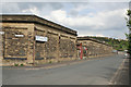
Weaving sheds on Warren Street
This former textile factory is now occupied by a major manufacturer of greetings cards. The lack of windows is typical of weaving sheds. These are lit by roof lights which give excellent lighting for this type of work; the other benefits are security and the lack of distraction for the workforce.
Image: © Alan Murray-Rust
Taken: 20 May 2007
0.02 miles
2
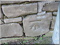
Ordnance Survey Cut Mark
This mark can be found on a wall in Warren Road.
For more details see : http://www.bench-marks.org.uk/bm41883
Image: © Peter Wood
Taken: 11 Mar 2012
0.03 miles
3
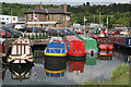
Dewsbury Canal Basin
The main line of the Hebble and Calder navigation cuts off the large loop of the River Calder which passes through the centre of Dewsbury. A branch o just under 1 mile in length was built to allow canal traffic better access to the mills in Dewsbury itself.
Image: © Alan Murray-Rust
Taken: 20 May 2007
0.04 miles
4
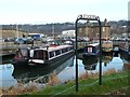
Dewsbury Marina
This is at the end of the Dewsbury branch canal off the Calder and Hebble Navigation. The 'Leggers' sign is for the marina's public house.
Image: © Humphrey Bolton
Taken: 10 Jan 2013
0.06 miles

6

Savile Town Basin
The terminus of the Dewsbury Arm, on the Calder & Hebble Navigation.
Image: © Christine Johnstone
Taken: Unknown
0.06 miles
7

Dewsbury Canal Basin - The Leggers Inn
The old canal wharf buildings now house a pub, coffee shop and chandlery.
'Leggers' were men employed to work canal boats through tunnels where there was no towpath. They would lie on their back or side and propel the boat by 'walking' (legging) along the canal walls or roof. There were in fact no tunnels in this immediate area.
Image: © Alan Murray-Rust
Taken: 20 May 2007
0.07 miles

9

Savile Town Wharf, Dewsbury
Looking westward from The Leggers Inn. The Wharf is a spur off the Calder and Hebble Navigation.
Image: © Peter Wood
Taken: 1 Jan 2018
0.07 miles
10

Calder and Hebble Navigations Dewsbury Arm #4
A fleet of very well tended narrowboats tied up at Dewsbury Marina.
Image: © Bobby Clegg
Taken: 11 Aug 2015
0.07 miles