IMAGES TAKEN NEAR TO
Princess Lane, DEWSBURY, WF12 8HD
Introduction
This page details the photographs taken nearby to Princess Lane, WF12 8HD by members of the Geograph project.
The Geograph project started in 2005 with the aim of publishing, organising and preserving representative images for every square kilometre of Great Britain, Ireland and the Isle of Man.

There are currently over 7.5m images from over14,400 individuals and you can help contribute to the project by visiting https://www.geograph.org.uk
Image Map
Images are licensed for reuse under creativecommons.org/licenses/by-sa/2.0
Notes
- Clicking on the map will re-center to the selected point.
- The higher the marker number, the further away the image location is from the centre of the postcode.
Image Listing (73 Images Found)
Images are licensed for reuse under creativecommons.org/licenses/by-sa/2.0
Image
Details
Distance
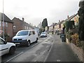
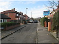
2

Princess Lane - looking towards Syke Lane
Image: © Betty Longbottom
Taken: 4 Dec 2013
0.06 miles
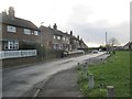
3

Bank View - looking towards Princess Lane
Image: © Betty Longbottom
Taken: 4 Dec 2013
0.06 miles
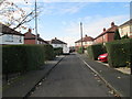
4

Westfield Avenue - looking towards Syke Lane
Image: © Betty Longbottom
Taken: 4 Dec 2013
0.07 miles

7
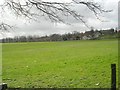
Recreation Ground - Wakefield Road, Earlsheaton
Image: © Betty Longbottom
Taken: 1 Mar 2008
0.09 miles
10
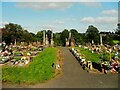
Earlsheaton Cemetery
Plenty of flowers and spme old grave monuments.
Image: © Humphrey Bolton
Taken: 17 Aug 2023
0.11 miles