IMAGES TAKEN NEAR TO
Leeds Road, DEWSBURY, WF12 7QW
Introduction
This page details the photographs taken nearby to Leeds Road, WF12 7QW by members of the Geograph project.
The Geograph project started in 2005 with the aim of publishing, organising and preserving representative images for every square kilometre of Great Britain, Ireland and the Isle of Man.

There are currently over 7.5m images from over14,400 individuals and you can help contribute to the project by visiting https://www.geograph.org.uk
Image Map
Images are licensed for reuse under creativecommons.org/licenses/by-sa/2.0
Notes
- Clicking on the map will re-center to the selected point.
- The higher the marker number, the further away the image location is from the centre of the postcode.
Image Listing (31 Images Found)
Images are licensed for reuse under creativecommons.org/licenses/by-sa/2.0
Image
Details
Distance
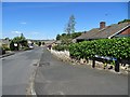
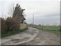
3
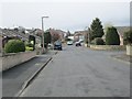
Willerton Close - looking towards Chidswell Lane
Image: © Betty Longbottom
Taken: 27 Apr 2013
0.04 miles
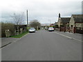
5
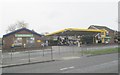
Jet Filling Station & Londis Store - Leeds Road
Image: © Betty Longbottom
Taken: 27 Apr 2013
0.07 miles
6

Red Ferrari at the "Jet" station in Chidswell
Image: © Neil Theasby
Taken: 22 Jun 2018
0.07 miles
8
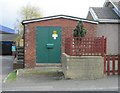
Electricity Substation No 5/591 - Chidswell Lane
Image: © Betty Longbottom
Taken: 27 Apr 2013
0.08 miles
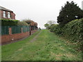
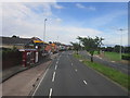
9
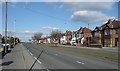
Leeds Road, Earlsheaton
The houses on each side of this road are ribbon development, mostly with fields behind. They had their front gardens drastically shortened when the road was widened to two carriageways.
Image: © Humphrey Bolton
Taken: 4 Mar 2010
0.08 miles