IMAGES TAKEN NEAR TO
Kirkgate, WAKEFIELD, WF1 1HU
Introduction
This page details the photographs taken nearby to Kirkgate, WF1 1HU by members of the Geograph project.
The Geograph project started in 2005 with the aim of publishing, organising and preserving representative images for every square kilometre of Great Britain, Ireland and the Isle of Man.

There are currently over 7.5m images from over14,400 individuals and you can help contribute to the project by visiting https://www.geograph.org.uk
Image Map
Images are licensed for reuse under creativecommons.org/licenses/by-sa/2.0
Notes
- Clicking on the map will re-center to the selected point.
- The higher the marker number, the further away the image location is from the centre of the postcode.
Image Listing (769 Images Found)
Images are licensed for reuse under creativecommons.org/licenses/by-sa/2.0
Image
Details
Distance
1
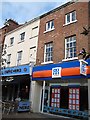
Nos 11 and 13, Upper Kirkgate
This grade II listed building dates back to the late C18 or early C19. It consists a 5-storey, 5-bay red brick house with stone moulded and modillion eaves cornice to a low pitched stone flagged roof. Modern shop fronts have been added.
Image: © Mike Kirby
Taken: 22 Feb 2009
0.00 miles
2
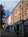
No 17, Upper Kirkgate
This grade II listed building dates back to the 2nd quarter of C19. It consists a 2-storey, 2-bay red brick house with stone frieze and moulded eaves cornice to a Welsh slate roof. A modern shop front has been added.
Image: © Mike Kirby
Taken: 22 Feb 2009
0.01 miles
4
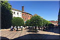
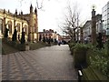
Clipped Holm Oaks in pedestrianised Kirkgate, Wakefield
Originally a wide street, now a pleasing traffic-free formal space lined with shops. The kirk was the parish church, which later became a cathedral. The crosses formed in the paving pattern maintain the association with the church.
Image: © Robin Stott
Taken: 30 Jun 2018
0.01 miles
5
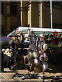
Hats on sale at Wakefield
A stall selling hats of various sizes and styles by the walls of the cathedral.
Image: © Stephen McKay
Taken: 30 Jun 2018
0.02 miles
6
Nos 19 and 21, Upper Kirkgate
This grade II listed building dates back to the late C18. It consists a 2-storey 5-bay house, red brick with stone moulded and modillion eaves cornice, with a fairly low pitched, hipped stone-flagged roof. Three original sash windows with glazing bars remain on 2nd floor. A modern shop front has been added.
Image: © Mike Kirby
Taken: 22 Feb 2009
0.02 miles
7
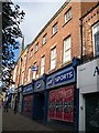
Boots the Chemist, 26-28 Upper Kirkgate
Boots store stands on an ancient site. Note the blue plaque on the right hand side of the building. Image
Image: © Mike Kirby
Taken: 23 Aug 2009
0.02 miles
8
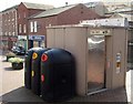
Recycling centre?
Have Wakefield MDC taken recycling to a whole new level?
Image: © Mike Kirby
Taken: 7 Sep 2008
0.02 miles
9
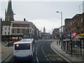
The Cathedral Walk Pedestrian Precinct, Wakefield
Image: © Bill Henderson
Taken: 30 Dec 2011
0.02 miles
10
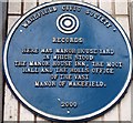
Blue Plaque, Boots store
This plaque is displayed on Boots store in Upper Kirkgate.
Image: © Mike Kirby
Taken: 23 Aug 2009
0.02 miles