IMAGES TAKEN NEAR TO
Great North Road, KNOTTINGLEY, WF11 0AD
Introduction
This page details the photographs taken nearby to Great North Road, WF11 0AD by members of the Geograph project.
The Geograph project started in 2005 with the aim of publishing, organising and preserving representative images for every square kilometre of Great Britain, Ireland and the Isle of Man.

There are currently over 7.5m images from over14,400 individuals and you can help contribute to the project by visiting https://www.geograph.org.uk
Image Map
Images are licensed for reuse under creativecommons.org/licenses/by-sa/2.0
Notes
- Clicking on the map will re-center to the selected point.
- The higher the marker number, the further away the image location is from the centre of the postcode.
Image Listing (7 Images Found)
Images are licensed for reuse under creativecommons.org/licenses/by-sa/2.0
Image
Details
Distance
1
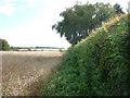
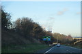
Grove Hall, Near Ferrybridge
Grove Hall is accessed from the southbound carriageway of the A1, south of Ferrybridge. It is in the north eastern corner of the O/S grid it occupies.
Image: © Bill Henderson
Taken: 18 Sep 2006
0.05 miles
2
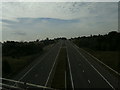
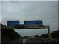
All quiet
The old A1M at Ferrybridge. Taken from the M62.
Image: © Ian S
Taken: 24 Jul 2010
0.17 miles
6
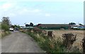
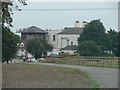
Business Premises of 'Wandahome' Caravan Sales
Image: © Bill Henderson
Taken: 15 Oct 2007
0.24 miles